Local Administrative Maps
江西十三府道里圖
Atlas of Jiangxi Province| Hanyu Pinyin | Jiangxi shi san fu daoli tu |
|---|---|
| Date | Mid-Kangxi period, 1682-1691. |
| Measurement | |
| Techniques | Ink and color manuscript on silk |
| Material | silk |
| Quantity | |
| Categories | |
| Country of Repository | |
| Identifier | British Library |
| Link to Original Database | http://explore.bl.uk/primo_library/... |
| Notes | Add. MS. 16356 |
| Share |
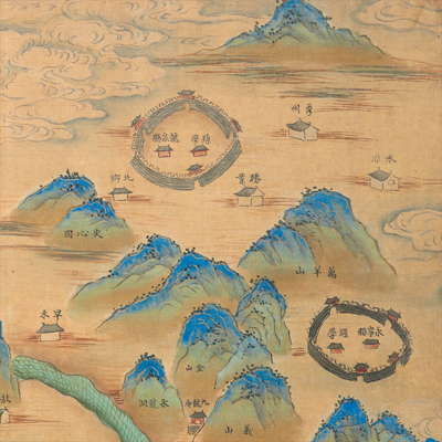
The atlas consists of 14 color silk maps: a general map of Jiangxi Province and 13 maps of prefectures including Nanchang, Raozhou, Fuzhou, Guangxin, Linjiang, Nankang, Ruizhou, Jiujiang, Yuanzhou, Jianchang, Ji’an, Ganzhou, Na’an, and 75 counties. No scale or legend is given; orientation is marked along the left and right border, indicating east and west. North is at the bottom. Boundaries of adjacent counties are marked along the margins on all four sides on each map.
The atlas depicts geographic features pictorially: mountains are colored in green in traditional texture brushstroke (Cunfa); rivers in emerald green in a fish scale pattern. The Yangtze River flows through the northern part of the territory; rivers within each jurisdiction run in an intricate pattern; lakes in the northern part are wide; the largest is the Boyang Lake; some segments describe sandbars, beaches, or dunes, showing some of the riverbed’s characteristics of the Yangtze River. Prefectures, municipality, and counties are indicated with ringed town walls; government offices, villages, bridges, temples, rest stations, schools are also clearly depicted pictorially supplemented with explanatory text. The map may have been drawn during the 21st and the 30th year of Kangxi’s reign, 1682-1691.
This map can be contrasted with the following maps in the National Palace Museum’s collection: Jiangxi Sheng quan tu (map no. 021298); Jiangxi Ji’an Fu tu (map no. 021462); Jiangxi tu (map no. 021474); Jiangxi quan sheng dao li tu (map no. 021528-9); Jiangxi Nanchang Fu shu ba zhou xian di yu tu (map no. 021532); Jiangxi Raozhou shu qi xian di yu tu (map no. 021533); Jiangxi Guangxin Fu shu qi xian di yu tu (map no. 021534); Jiangxi Jiujiang fu shu wu xian di yu tu (map no. 021535); Jiangxi Jianchang Fu shu wu xian di yu tu (fmap no. 021536); Jiangxi Fuzhou Fu shu liu xian di yu tu (map no. 021537); Jiangxi Nankang fu shu si xian di yu tu (map no. 021592); Jiangxi Linjiang si xian di yu tu (map no. 021593); Jiangxi Yuanzhou fu shu si xian di yu tu (map no. 021594); Jiangxi Ji’an fu fu shu si xian di yu tu (map no. 021595); Jiangxi Ruizhou fu shu san xian di di yu tu (map no. 021596); Jiangxi Ganzhou fu shu shi er xian di yu tu (map no. 021597); Jiangxi Na’an fu shu si Xian di yu tu (map no. 021598); and the Library of Congress collection: Jiangxi quan tu (gm 71005118).