Local Administrative Maps
晉省地輿全圖
Map of Shanxi Province| Hanyu Pinyin | Jin Sheng di yu quan tu |
|---|---|
| Creator | Li Shifu |
| Date | The 59th year of Qing Qianlong's reign, 1794. |
| Measurement | |
| Techniques | Woodcut on paper |
| Quantity | |
| Categories | |
| Country of Repository | |
| Identifier | British Library |
| Link to Original Database | http://explore.bl.uk/primo_library/... |
| Notes | Maps S.T.S.82 |
| Share |
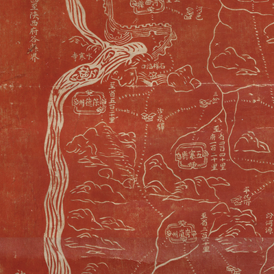
Title is written on the upper right. No scale, legend, or orientation is given, but north is obviously at the top. The map uses the traditional Chinese pictorial style to depict mountains, rivers, cities, and the Great Wall. It is a composition map with simple lines, but captures the essence of nine prefectures, ten municipalities, six sup-prefectures, and the respective counties, at the same time, rendered a vivid depiction of the geographic terrain of Shanxi’s mountains and rivers. The map treats all levels of government in the same way regardless of prefecture, municipality, or county; the pattern is similar throughout the map. There is annotation for Shanxi, neighboring provinces and counties, posts, roads, and mileage on the map. The Yellow River line is a little bit straight to mark the boundary of Shanxi and Shaanxi. The Great Wall winds in the northern Shanxi territory and gives the map a three-dimensional feel.
On the bottom left, the date of completion, 1794, and the signature of mapmaker Li Shifu appears. Not much biographical information was known about Li Shifu except that he was an excellent painter.
This map can be contrasted with the following maps in the National Palace Museum’s collection: Shanxi quan sheng dao li zong tu (map no. 021590-021591); Shanxi Sheng yu di tu shuo (map no. 021300); Shanxi Sheng di tu (map no. 021483); and the Library of Congress collection: Shanxi quan tu (gm 71005110); Shanxi Sheng cheng jie dao ji fu jin tan miao cun zhuang tu (gm 71005056).