City Maps
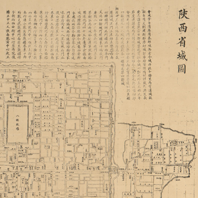
陜西省城圖
Urban map of Xi'an, capital of Shaanxi Province| Hanyu Pinyin | Shaanxi Sheng yu tu guan Shaanxi Sheng cheng tu |
|---|---|
| Creator | Shaanxi Sheng yu tu guan |
| Date | The 19th Year of Qing Reign, 1893 |
| Measurement | |
| Techniques | Woodcut |
| Material | paper |
| Quantity | |
| Categories | |
| Country of Repository | |
| Identifier | Library of Congress |
| Link to Original Database | http://lccn.loc.gov/gm71005147 |
| Acquisition Method | |
| Acquisition Date |
| Share |
The map locates and describes the buildings of Xi'an City. Notes on the top of the map describe the establishment of Mancheng city during the Qing Dynasty and the construction history of Xi'an. Also included are the distribution of government offices and temples, the process of making the map, and the scale used for the map. The map, based on a survey, has an expressed scale, with each side of a square representing fifty feet. The city of Xi'an has a perimeter of 4,390 feet.. From east to west is 1,370 feet, and north to south is 825 feet. Mancheng city has a perimeter of 2,630 feet, and extends 740 feet from east to west and 575 feet from north to south. The left inscription is recorded by a surveyor; the map was made in October of the 19th Year of Qing Guangxu Reign (1893).
This map can be studied with the following map in the National Palace Museum's collection: title: Shaanxi di tu (purchase no. 002584).
This map can be studied with the following map in the National Palace Museum's collection: title: Shaanxi di tu (purchase no. 002584).