City Maps
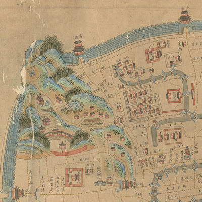
浙江省垣坊巷全圖
City plan of Hangzhou, capital of Zhejiang Province| Hanyu Pinyin | Zhejiang Sheng yuan fang xiang quan tu |
|---|---|
| Creator | Anonymous |
| Date | The 6th Year of Qing Tongzhi Reign, 1867 |
| Measurement | |
| Techniques | Ink and color manuscript |
| Material | |
| Quantity | |
| Categories | |
| Country of Repository | |
| Identifier | Library of Congress |
| Link to Original Database | http://lccn.loc.gov/gm71005032 |
| Acquisition Source | Hummel, Arthur William, 1884-1975 |
| Acquisition Method | |
| Acquisition Date | 1930 |
| Share |
Orientation is indicated along the margins of the map with north to the right; the map combines the traditional pictorial style with three-dimensional images, and it also depicts the architectural layout of Hangzhou city in Zhejiang Province. The map shows streets, canals, bridges, government offices, and temples. Hangzhou City, city walls, and gates are portrayed in blue three-dimensional images; rivers in double blue lines extend all the way to the outside of the city; streets are in yellow dotted lines. Fenghuang Mountain in the Southwest and the buildings constructed on the top are illustrated in meticulous detail.
The map can be studied with the following maps in the National Palace Museum's collection: title: Zhejiang Hangzhou fu di yu tu shuo (map no. 021305); title: Hangzhou tu (map no. 021484); title: Zhejiang Hangzhou fu dao li tu (map no. 021531).
The map can be studied with the following maps in the National Palace Museum's collection: title: Zhejiang Hangzhou fu di yu tu shuo (map no. 021305); title: Hangzhou tu (map no. 021484); title: Zhejiang Hangzhou fu dao li tu (map no. 021531).