City Maps
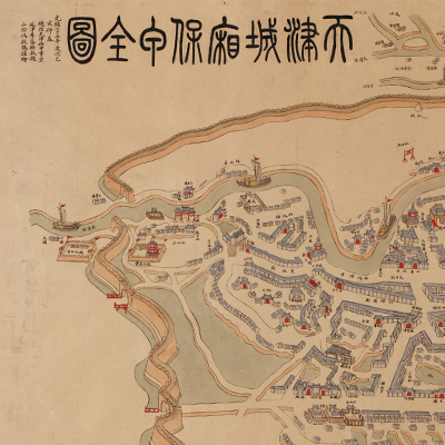
天津城廂保甲全圖
Complete map of the community self-defense system of the walled city of Tianjin and its environs| Hanyu Pinyin | Tianjin cheng xiang bao jia quan tu |
|---|---|
| Creator | Feng Qihuang |
| Date | The 25th Year of Qing Guangxu Reign, 1899 |
| Measurement | |
| Techniques | Ink and color manuscript |
| Material | |
| Quantity | |
| Categories | |
| Country of Repository | |
| Identifier | Library of Congress |
| Link to Original Database | http://lccn.loc.gov/gm71005155 |
| Acquisition Method | |
| Acquisition Date | 1952 |
| Share |
The notes on the upper left are inscribed by the local official Li Yinwu, for whom the map was made. The map presents a bird's-eye view of Tianjin and is not drawn to scale. North is oriented toward the upper left. The map depicts the old city, the Hai River, and the streets and buildings along the Grand Canal. The map also shows government administrative buildings, temples, factories, concessions, Western-style houses, rivers, bridges, and army encampments. The Jin Lu Railway (from Tianjin to the Marco Polo Bridge) and the Jin Yu Railway (from Tianjin to Shanhaiguan) are not drawn to scale.
The map reflects the city's development and changes after the city was opened for foreign trade in the late nineteenth century. The mapping style remains predominately traditional with new elements added; factories in the south and northeast are drawn with smoke coming out of chimneys. The map is considered a typical Chinese city map of the late nineteenth century.
The map can be studied with the following maps in the National Palace Museum's collection: title: Tianjin Haikou tian she shui shi ying xun tu shuo (Grand Council file no. 051101); title: Jinpu tie lu Tianjin zhan tai guan yu shang wu li hai bi jaio cao tu (Grand Council file no. 187930-a); title: Jinpu Tianjin zong zhan lu xian tu shuo (Grand Council file no. 188016).