City Maps
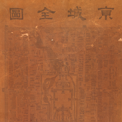
京城全圖
Map of Beijing| Hanyu Pinyin | Jing cheng quan tu |
|---|---|
| Creator | Anonymous |
| Date | Mid-Qing period, 1830-1870 |
| Measurement | |
| Techniques | Woodcut |
| Material | linen |
| Quantity | |
| Categories | |
| Country of Repository | |
| Identifier | Library of Congress |
| Link to Original Database | http://lccn.loc.gov/92682865 |
| Share |
The map applies the traditional Chinese landscape style with pictorial shapes and symbols to depict the capital city, including the outline and layout of the city walls, streets, alleys, rivers, lakes, and bridges. Government offices, warehouses, temples, and other buildings are identified with annotations. “The Temple of Heaven” and “The Altar of the God of Agriculture” are symbolized with images; the imperial compound called the “Forbidden City” is indicated, but nothing else inside is described; the Jing Mountain is depicted with five pavilions on the top. The map is definitely an urban map of the capital city, not a royal map for emperors; the imperial Forbidden City was left blank while the alleys are described in detail. The map has faded, however, many similar outline maps of Beijing have survived.
The map can be studied with the following maps in the National Palace Museum's collection: title: Beijing gong dian tu (map no. 021470); title: Huang cheng gong dian ya shu tu (map no. 021601)
The map can be studied with the following maps in the National Palace Museum's collection: title: Beijing gong dian tu (map no. 021470); title: Huang cheng gong dian ya shu tu (map no. 021601)