City Maps
北京全圖
Complete map of Beijing| Hanyu Pinyin | Beijing quan tu |
|---|---|
| Creator | Li Mingzhi |
| Date | Qing Guangxu period, 1861-1887 |
| Measurement | |
| Techniques | Ink and color manuscript |
| Quantity | |
| Categories | |
| Country of Repository | |
| Identifier | Library of Congress |
| Link to Original Database | http://lccn.loc.gov/gm71005149 |
| Share |
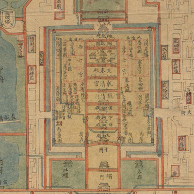
The map depicts the outline of city walls, water systems, streets, and buildings with special emphasis on the alleys around the main streets in the inner city. The alleys outside the inner city are not named or colored. Government offices, palaces, mansions, temples, and churches are identified and colored, particularly the Forbidden City, the Imperial City, the royal gardens and architecture, foreign embassies, the Temple of Heaven, and the Altar of the God of Agriculture. There are some place name errors on the map.
Notes on the bottom left: Drawn by Beijing student Li Mingzhi. The map was drawn between 1861 and 1887.
The map can be can be studied with the following maps in the National Palace Museum's collection: title: Huang cheng gong dian ya shu tu (map no. 021601); title: Beijing gong dian tu (map no. 021470).