City Maps
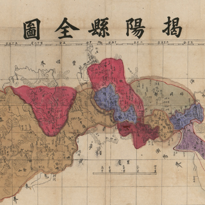
揭陽縣全圖
Complete map of Jieyang County| Hanyu Pinyin | Jieyang xian quan tu |
|---|---|
| Creator | L., William, missionary to China |
| Date | Late Qing period, 1875- |
| Measurement | |
| Techniques | Ink and color manuscript |
| Material | |
| Quantity | |
| Categories | |
| Country of Repository | |
| Identifier | Library of Congress |
| Link to Original Database | http://lccn.loc.gov/89691148 |
| Share |
The map covers the area 115° 45′E - 116° 40′E / 23° 15′E -23° 45′N. The prime Meridian is Greenwich. The map depicts the territory and topography of Jieyang County in Guangdong Province. Different colors represent levels of administrative divisions. The scale is approximately 1:167,000. Relief is shown by hachures. The map and information given are fairly accurate; mapping techniques are similar to western maps at the end of the nineteenth century.
The map can be studied with the following maps in the National Palace Museum's collection: title: Guangdong Sheng shu ge zhou fu xian di yu tu shuo (map no. 021157); title: Guangdong Sheng di tu (map no. 021477).
The map can be studied with the following maps in the National Palace Museum's collection: title: Guangdong Sheng shu ge zhou fu xian di yu tu shuo (map no. 021157); title: Guangdong Sheng di tu (map no. 021477).