Military and Traffic Maps
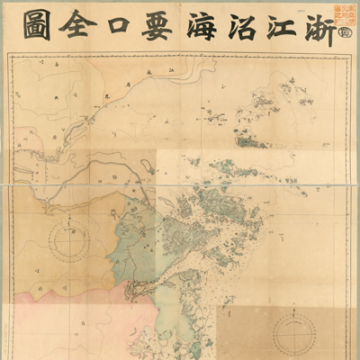
浙江沿海要口全圖
Map of the coast forts in Zhejiang Province| Hanyu Pinyin | Zhejiang yan hai yao kou quan tu |
|---|---|
| Creator | Shen Yingjing (facsimile copy) |
| Date | Late Qing period, 1902-1911 |
| Measurement | |
| Techniques | Lithograph, hand-colored |
| Material | paper |
| Quantity | |
| Categories | |
| Country of Repository | |
| Identifier | Library of Congress |
| Link to Original Database | http://lccn.loc.gov/2002626763 |
| Acquisition Date | 1915.12.15 |
| Share |
This map differs from other Qing Dynasty maps by using modern features such as legends, compass roses, cylindrical projections, Greenwich coordinates, and hachures for landform relief. The longitude and latitude coordinates are E120° 35' to 123° 5' and N27° 50' to 31°. The map covers territory from the junction of Hangzhou Bay and Jiangsu Province in the north to the Oujiang estuary of Wenzhou Prefecture in the south, excluding the places south of Wenzhou. The map features coastal landforms of six important ports: Jiaxing in Zhejiang Province, Hangzhou, Shaoxing, Ningbo, Taizhou, and Wenzhou. The map also provides a detailed descriptions of the island, shoal, reef, river current, bridges, towns, houses, seawall, beach, streams, and marks waterways and the water depth.
The lithograph map may have been printed between 1902 and 1911, after the
disintegration of the Qing Dynasty. The map shows prefectures and municipalities as government administrative divisions; military training camps were set up in Beijing in 1902 and every province in 1904. In 1911 the Beiyang government abolished the administrative levels of prefectures and municipalities, and implemented a two-tier system of provinces and counties. The facsimile copier, Shen Yingjing, a Zhejiang army officer at the General Staff Department of Surveying and Mapping, signed the map.
This map can be studied with the following maps in the National Palace Museum's collection: title: Zhejiang Sheng hai tang (map no. 020880); title: Zhejiang Qiantang Jiang shui lu tu (Grand council document no 033184); title: Zhejiang Fujian yan hai hai fang tu (map no. 020869); title: Zhejiang Hangzhou Fu di yu tu shuo (map no. 021305); title: Zhejiang Jiaxing Fu di yu tu shuo (map no. 021306); title: Zhejiang Ningpo Fu shu di li yu tu (map no. 021308); title: Zhejiang Shaoxing Fu di yu tu shuo (map no. 021309); Zhejiang Taizhou Fu di yu tu shuo (map no. 021310); title: Zhejiang Wenzhou Fu shu di yu tu shuo (map no. 021312).