Military and Traffic Maps
北洋分圖
Coastal map of the North China| Hanyu Pinyin | Bei Yang fen tu |
|---|---|
| Creator | Hubei Guan Shu Ju |
| Date | After 9th Year of Qing Tongzhi Reign, 1870- |
| Measurement | |
| Techniques | Woudcut |
| Material | paper |
| Quantity | |
| Categories | |
| Country of Repository | |
| Identifier | Library of Congress |
| Link to Original Database | http://lccn.loc.gov/gm71005226 |
| Acquisition Date |
| Share |
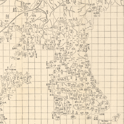
This map and three others, “Nan Bei Yang he tu”, “Nan Yang fen tu”, and “Dian, Yue, Yuenan lian jie yu tu”, belong to the same set. Text at the bottom left states that the Chinese cartographic grid is applied and a side of each grid represents 100 li (approximately 33 miles). Different symbols represent different administrative divisions, such as provincial capitals, counties, cities, mills, and checkpoints. The map depicts northern China's coastal terrain. The map covers territory from northern Jiangsu Province to the southern Yellow River mouth; north reaches to the Hilo River estuary in Russia (Xilin River). The map also shows Zhili (Hebei) in the northeast, Shandong, Fengtian (Liaoning), river systems, the Korean Peninsula, coastal territories, and islands. The Korean Peninsula is mapped in great detail.
This map can be studied with the following maps in the National Palace Museum's collection: title: Bei Yang hai an tu (map no. 021554; title: Xun yue Bei Yang hai fang tu (map no. 021555).
This map can be studied with the following maps in the National Palace Museum's collection: title: Bei Yang hai an tu (map no. 021554; title: Xun yue Bei Yang hai fang tu (map no. 021555).