Military and Traffic Maps
南北洋合圖
Coastal map of Imperial Qing| Hanyu Pinyin | Nan Bei Yang he tu |
|---|---|
| Creator | Hubei Guan Shu Ju |
| Date | After 9th Year of Qing Tongzhi Reign, 1870- |
| Measurement | |
| Techniques | Woudcut |
| Material | paper |
| Quantity | |
| Categories | |
| Country of Repository | |
| Identifier | Library of Congress |
| Link to Original Database | http://lccn.loc.gov/gm71005215 |
| Acquisition Date |
| Share |
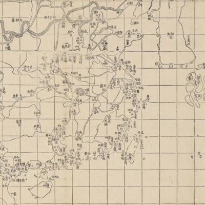
The maps “Bei Yang fen tu”, “Nan Yang fen tu”, and “Dian, Yue, Yuenan lian jie yu tu” belong to the same set. Text at the bottom left notes that the Chinese cartographic grid is used and and a side of each grid represents 400 li (approximately 132 miles). The map covers the entire east coast of Asia from the Kamchatka Peninsula in the north to the Indochina Peninsula in the south, including Japan, the Korean peninsula, and the mainland of China. The map depicts coastal terrain of China's northern and southern sea frontier. The map shows major rivers and the surrounding islands, borders and provincial boundaries, the Great Wall, and some cities. Coastal place names are described more in detail than places inland. Bei Yang and Nan Yang ministers were put stal affairs and the jurisdiction dividing line was from the northern part of Jiangsu Province to the silt of the Yellow River mouth.
This map can be studied with the following maps in the National Palace Museum's collection: title: Bei Yang hai an tu (map no. 021554); title: Xun yue Bei Yang hai fang tu (map no. 021555).
This map can be studied with the following maps in the National Palace Museum's collection: title: Bei Yang hai an tu (map no. 021554); title: Xun yue Bei Yang hai fang tu (map no. 021555).