Military and Traffic Maps
七省沿海全圖
Coastal Map of China| Hanyu Pinyin | Qi sheng yan hai quan tu |
|---|---|
| Creator | Jin Baoyi |
| Date | The 7th Year of Qing Guanxu Reign, 1881 |
| Measurement | |
| Techniques | Ink manuscript |
| Material | paper |
| Quantity | |
| Categories | |
| Country of Repository | |
| Identifier | Library of Congress |
| Link to Original Database | http://lccn.loc.gov/gm71005064 |
| Acquisition Source | Hummel, Arthur William, 1884-1975 |
| Acquisition Method | |
| Acquisition Date | 1962 |
| Share |
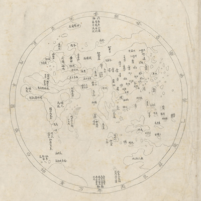
The map scroll is a handmade facsimile of “Hai jiang yang jie xing shi quan tu”. The map consists of six maps and is meant to be spread out from right to left and expand slowly with captions as follows: 1. Huan Hai quan tu; 2. Qi sheng yan hai quan tu; 3. Qiongzhou tu; 4. Penghu tu; 5. Taiwan tu; 6. Taiwan hou shan tu. Coastal maps are usually drawn in two styles, depending on the location and purpose: either land or sea is put at the top of the map. On this map, land is at the top and the sea is on the bottom. Orientation varies and the places shown reflect only their relative locations. The map depicts the coast, including mountains, islands, reefs, sandbars, and ports. Provincial, state, county, town, village, and flood control offices are represented by symbols. Provinces, states, and counties are indicated with squares; towns and villages are represented with circles. The Shanhaiguan pass, the Great Wall, some bridges, towers, and forts are disproportionately sketched. Explanatory text after each map describes mountains, rivers, military facilities, coastal defenses, waterways, nautical routes, and anchorage.
The map was copied from “Hai jiang yang jie xing shi quan tu”, but several typographical errors on the map were corrected; on the map of Taiwan, Zhuluo County was replaced with Jiayi County; the location of Jiayi County was also corrected.
The notes by Jin Baoyi at the end of the map state: “This scroll was in the private collection of Hong's family in Chicheng City. Yang Junzhong, who was from the same town, got hold of the map and showed it to me; I copied the map in order to use it together with the book of “Chou hai bei yao”. I didn't copy the map just for an addition to my library's collection.” The notation is dated “Guangxu Xinsi 7 nian” (1881), and was signed by Jin Baoyi from Jiangyin in early autumn.
This map can be studied with the following maps in the National Palace Museum's collection: title: Hai tu (map no. 020865); title: Ge sheng yan hai kou ai quan tu (map no. 020867); title: Yan hai an chang tu (map no. 020868); title: Zhejiang Fujian yan hai hai fang tu (map no. 020869).