Military and Traffic Maps
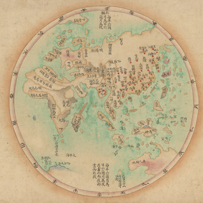
海疆洋界形勢全圖
Coastal map of China| Hanyu Pinyin | Hai jiang yang jie xing shi quan tu |
|---|---|
| Creator | Anonymous |
| Date | Mid-Qing period, 1787-1801 |
| Measurement | |
| Techniques | Ink and color manuscript |
| Material | paper |
| Quantity | |
| Categories | |
| Country of Repository | |
| Identifier | Library of Congress |
| Link to Original Database | http://lccn.loc.gov/gm71005063 |
| Acquisition Source | Hummel, Arthur William, 1884-1975 |
| Acquisition Method | |
| Acquisition Date | 1962 |
| Share |
The map is made on scrolls and is similar to the other two maps of the same theme: “Hai jiang yang jie xing shi tu”and “Hai jiang yang jie xing shi quan tu.” The map consists of six parts on the scroll and is meant to be spread out from right to left and expand slowly with captions as follows: 1. Huanhai quan tu; 2. Qi sheng yan hai quan tu; 3. Qiongzhou tu; 4. Penghu tu; 5. Taiwan tu; 6.
Taiwan hou shan tu.
Coastal maps are usually drawn in two styles depending on location and purpose. Either land or sea is put at the top of the map. On this map, land is at the top and the sea is positioned on the bottom. Orientation varies and the places shown reflect only their relative locations. The map depicts geographical features such as coast, mountains, islands, reefs, sandbars, and ports. Provinces, states, and counties are indicated with squares; towns and villages are represented with circles. The Shanhaiguan pass, the Great Wall, some bridges, towers, and forts are disproportionately sketched. There is explanatory text after each map to describe mountains, rivers, military facilities, coastal defenses, waterways, nautical routes, and anchorages.
This map can be studied with the following maps in the National Palace Museum's collection: title: Ge sheng yan hai kou ai quan tu (map no. 020867). The map made some revisions based on the map of “Tian xia yan hai xing shi lu” by Chen Lunjiong (dates unknown, style name Cian, served as Taiwan general in 1726 and later as Zhejiang Admiral). There are other maps made on the coast, and most of them copied from Chen Lunjiong's original map. (see item no. 012886-012887).
There are several typographical errors on the map; for instance, on the map of Taiwan, Zhanghua County was misidentified as Jiayi County. It coexisted at the same time as Zhuluo Xian.
This map can be studied with the following maps in the National Palace Museum's collection: title: Hai tu (map no. 020865); title: Ge sheng yan hai kou ai quan tu (map no. 020867); title: Yan hai an chang tu (map no. 020868); title: Zhejiang Fujian yan hai hai fang tu (map no. 020869).