Military and Traffic Maps
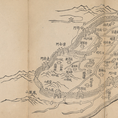
安瀾園至杭州府行宮道里圖說
Illustrated route map from Anlanyuan to Hangzhou| Hanyu Pinyin | Anlanyuan zhi Hangzhou Fu xing gong dao li tu shuo |
|---|---|
| Creator | Anonymous |
| Date | Qing Qianlong period, 1765-1780 |
| Measurement | |
| Techniques | Woodcut |
| Material | paper |
| Quantity | |
| Categories | |
| Country of Repository | |
| Identifier | Library of Congress |
| Link to Original Database | http://lccn.loc.gov/2002626740 |
| Share |
The map is folded and opens from right to left. The orientation and scale were not considered for this map. The map covers territory from Anlanyuan of Haining State in Zhejiang Province to the palaces in Hangzhou Fu. The map describes tidal seawalls, roads, bridges, river culverts and the tide gate dam project, as well as city plans. The accompanying notes at the end of the map give the distances between cities and roads; the notes also explained the Haitang seawall embankment project and the work to strengthen the tide gate dam.
This map, together with the map of “Anlanyuan zhi jian shan qi zuo dao li tu shuo” is a set of folded maps submitted to the emperor Qianlong on his southern inspection tour. “Stop number 4” is written under the title. Based on the Emperor Qianlong's inspection tour schedules, it is believed that the map was made between his fourth and fifth tours (1765-1780).
This map can be studied with the following maps in the National Palace Museum's collection: title: Qianlong nan xun ji cheng tu (map no. 020803-020818); title: Shimenzhen bei di er zhan zhi Haining Xian Tanglou Zhen Daying dao li tu shuo (map no. 020819); title: Tangkou Zhen di san zhan zhi sheng cheng nei xing gong dao li tu shuo (map no. 020820); title: Haining Chenyuan di si zhan zhi sheng cheng nei xing gong dao li tu shuo (map no. 020821); title: Qianlong si shi wu nian gong feng huang shang nan xun jing you Zhili dao lu tu shuo (Grand council document no. 022503).