Military and Traffic Maps
陜境蜀道圖
Annotated road map from Shaanxi to Sichuan| Hanyu Pinyin | Shan jing shu dao tu |
|---|---|
| Creator | Anonymous |
| Date | Mid-Qing period, 1750- |
| Measurement | |
| Techniques | Ink and color manuscript |
| Material | paper |
| Quantity | |
| Categories | |
| Country of Repository | |
| Identifier | Library of Congress |
| Link to Original Database | http://lccn.loc.gov/gm71005016 |
| Acquisition Source | Hummel, Arthur William, 1884-1975 |
| Acquisition Method | |
| Acquisition Date | 1930 |
| Share |
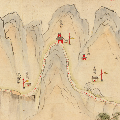
The map scroll depicts the areas of Baoji County, Feng County, Liubating Township, City of Baocheng, Mian County, Ningqiang State, and the Lianyun Plank Road of the Qipanguan bordering Qin Shu. The Lianyun Plank Road was the most important connection between the Central Plains and the Southwest during the Qing Dynasty. The map pictorially portrays the mountains, streams, bridges, plank roads, towns, relay stops, flood barriers, checkpoints, tea pavilions,
temples, monuments, and scenic spots. The map not only records place names, but also notes the management of county boundaries and the sources of river systems, etc. Each city was drawnvividly; morphological changes were captured from one scene to another.
The map is not only valued for its artistry, but also for its functionality. Merchants could travel freely between Shaanxi to Sichuan by following the annotated map; notes were added later on. Like the original text, later annotations contributed to the practicality and usefulness of the map. This map can be studied with the following map in the National Palace Museum's collection: title: Dong xiang xiu li zhan dao you by Xu Xin's report (grand council document no. 059660).