Military and Traffic Maps
孟河營繪呈卑營汛境江程里數界址圖
Military Map of the Menghe Naval Brigade in Yangtze River| Hanyu Pinyin | Meng He ying hui cheng bei ying xun jing |
|---|---|
| Creator | Anonymous |
| Date | Late Qing period, 1864- |
| Measurement | |
| Techniques | Ink and color manuscript |
| Material | paper |
| Quantity | |
| Categories | |
| Country of Repository | |
| Identifier | Library of Congress |
| Link to Original Database | http://lccn.loc.gov/80692825 |
| Acquisition Source | W.B. Nance |
| Acquisition Method | |
| Acquisition Date | 1912.05.06 |
| Share |
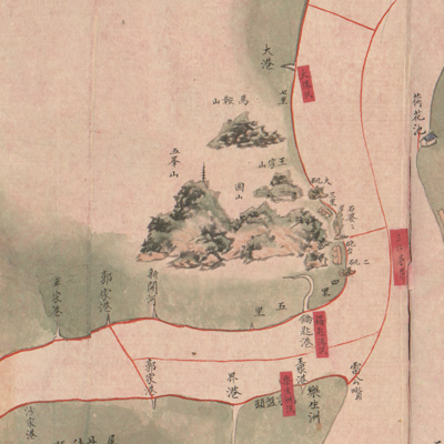
The map is typical of Qing Dynasty river defense maps. It is oriented with north at the bottom but the map isn't consistent with other features of the location. The map is folded and expands from right to left. The places on the south bank of the Yangtze River are described in a detailed annotation; only Taixing County on the north shore is depicted; all other places are omitted. The map covers territory from the west at Hujiagoukou in Zhenjiang to the east at Taohuakou in Wujin County. The Menghe Brigade fell under the jurisdiction of Guazhou Township and was responsible for deterring theft and smuggling, guarding checkpoints, and safeguarding the Yangtze River from invasion.
Coastal mountains, river ports, sandbars, towns, flood control centers, and forts are clearly marked. The mountains on the south bank of the Yangtze River are shown pictorially with traditional Chinese landscape painting. The sandbars along the river are shown in green; county boundaries in thin dark lines; brigadem boundaries in thin red lines; place names and distance mileage in black; flood zones and camps use red labels.
This map, together with the map of “Chang Jiang shui shi Guazhou zhen biao zhong ying jiang xu quan tu” is part of a set on the four camps under the command of the Guazhou general. It can be studied with the following maps in the National Palace Museum's collection: title: Chang Jiang di li tu (map no. 020878); title: Chang Jiang tu (map no. 020879); title: Guazhou jiang gong
tu (Grand council document no. 012448-a); title: Jing kou yi xia Xiyang Yunhe yi dai he hu zhi Hangzhou qing xing (map no. 020881).