Military and Traffic Maps
賓州廳鄉社全圖
Complete Map of the Townships and Communities of Binzhou Sub-Prefecture| Hanyu Pinyin | Binzhou Ting xiang she quan tu |
|---|---|
| Creator | Anonymous |
| Date | The 22nd Year of Qing Guangxu Reign, 1902 |
| Measurement | |
| Techniques | Ink and color manuscript |
| Quantity | |
| Categories | |
| Country of Repository | |
| Identifier | Library of Congress |
| Link to Original Database | http://lccn.loc.gov/gm71005247 |
| Acquisition Source | Hummel, Arthur William, 1884-1975 |
| Acquisition Method | |
| Acquisition Date | 1934 |
| Share |
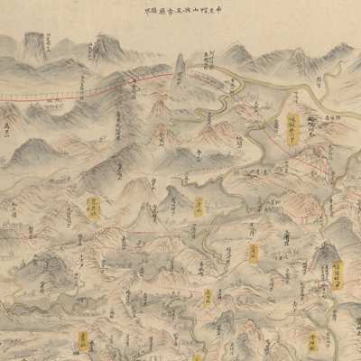
Binzhou sub-prefecture was established in the 7th Year of Qing Guangxu Reign (1881). It was promoted again in 1909 to prefecture level under the jurisdiction of the Jilin General. It is now Bin County, located in Heilongjiang Province in northeast China.
The map is not drawn to scale; north is oriented to the bottom. The map depicts mountains, towns, rivers, railways, villages, administrative offices, and military camps. Townships, communities, and new Chinese settlements are clearly indicated and labeled. Roads are indicated with dotted red lines, railways in red lines. The map also depicts railroad tracks outside Har'erbin on the bottom right. It was a part of the China Eastern Railway built by Russian interests from 1898 to 1903. The map was most likely drawn between 1898-1904.
The map can be studied with the following maps in the National Palace Museum's collection: title: Heilongjiang liu yu tu (map no. 021456); title: Jiling jiu he tu (map no. 021457).