Flood Control and Embankment Maps
湖北省長江、漢水堤工圖
Map of levee repairs in Hubei Province| Hanyu Pinyin | Hubei Sheng Chang Jiang, Han Shui ti gong tu |
|---|---|
| Creator | Anonymous |
| Date | Qing Daoguang period, 1821-1850 |
| Measurement | |
| Techniques | Ink and color manuscript |
| Material | paper |
| Quantity | |
| Categories | |
| Country of Repository | |
| Identifier | Library of Congress |
| Link to Original Database | http://lccn.loc.gov/gm71005075 |
| Acquisition Source | Hummel, Arthur William, 1884-1975 |
| Acquisition Method | |
| Acquisition Date | 1934 |
| Share |
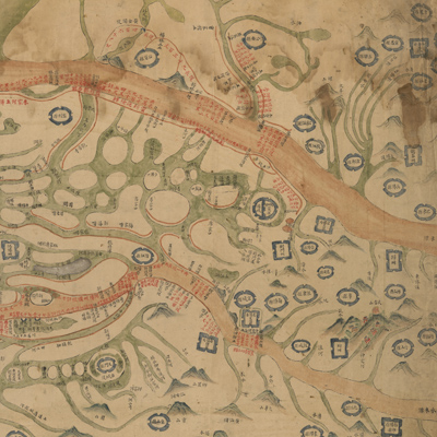
“Map of Yangtze” was written on the verso of the map. The caption seems inconsistent with the contents of the map and most likely was not written by the mapmaker. The map is oriented with north to the bottom and expands from right to left to view downstream from upstream of the Yangtze River and Han River.
The map covers territory from Badong County of Hubei Province in the west to Huangmei County near the junction of Hubei and Jiangxi in the east. The Yangtze River, Han River, and mountains are shown pictorially. The map shows the Yangtze and Han River in yellow-brown, other rivers in green, and riverbanks in dark brown. The different sizes and shapes of city walls are used as symbols to distinguish prefecture, municipality, and county; annotations record the construction of the embankment along the rivers.
All place names are annotated in black ink while embankment construction and repair work is written in red. The notes explain the respective segments assigned to each state and county. The red ink is applied only for special emphasis on the levee construction project from Jingjiang to Qizhou for the Yangtze River segment and from Xiangyang County to Hanchuan County for the Han River segment. The map illustrates the importance of embankment construction.
According to the "Study of Water Conservancy" in the Gazetteer of Tianmen County, “Han River south bank embankment is about 14,549 zhang (1 zhang equals approximately 3.33 meters)” in the 30th Year of Qing Qianlong Reign, 1765; the embankment was 16,867.5 zhang (1 zhang equals approximately 3.33 meters) by the 20th Year of Qing Daoguang Reign, 1840 (see: “Chu bei Dykes Minutes” by Yu Changlie). The length quoted in this book is almost the same as stated on the map. The map was probably drawn after the reign of Emperor Daoguang, 1821-1850.
This map can be studied with the following maps in the National Palace Museum's collection: title: Chang Jiang di li tu (map no. 020878); title: Chang Jiang tu (map no. 020879).