Flood Control and Embankment Maps
四川、湖北水道圖
Map of the waterways in Sichuan and Hubei Province| Hanyu Pinyin | Sichuan, Hubei shui dao tu |
|---|---|
| Creator | Anonymous |
| Date | Early-Qing period, 1735- |
| Measurement | |
| Techniques | Ink and color manuscript |
| Material | paper |
| Quantity | |
| Categories | |
| Country of Repository | |
| Identifier | Library of Congress |
| Link to Original Database | http://lccn.loc.gov/gm71005028 |
| Notes | Variant title Alternate title: Min Jiang tu shuo Alternate title: 岷江图说 Alternate title in English: Map of the waterways in Sichuan and Hubei Provinces |
| Share |
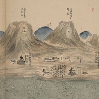
This map consists of 14 separate sheets in portfolio format. Orientation varies with river flow. Each sheet is marked with orientation on the top or bottom right. The map employs the traditional Chinese landscape style to describe the route of the Min River, moving from the Songpan Great Dividing Range that is the source of the Min River, downstream andnbypassing Chengdu, Chongqing, and the Three Gorges to Hubei Jingzhou Prefecture. The map depicts scenery along the river. Annotations, notes, poems, and historical texts are cited to describe the treacherous terrain and scenic attractions along the way.
The annotation cited “Historical geography: a compendium” by Gu Zuyu in the 31st Year of Qing Kangxi Reign (1692) indicates this map was made in Qing Dynasty. There are several obvious errors in the names and locations of the established administrative region for unknown reasons. Yichang was upgraded in the 13th Year of Qing Yongzheng Reign (1735). These facts suggest that this map was made between the early Qing era and the 13th Year of Qing Yongzheng Reign (1735).
This map can be studied with the following maps in the National Palace Museum's collection: title: Sichuan Sheng tu (map no. 021459); title: Sichuan quan sheng dao li zong tu (map no. 021540-021542).