Flood Control and Embankment Maps
錢塘江沿岸圖
Coastal map of Qiantang River| Hanyu Pinyin | Qiantangjiang yan an tu |
|---|---|
| Creator | Anonymous |
| Date | Mid-Qing period, 1775-1809 |
| Measurement | |
| Techniques | Ink and color manuscript |
| Material | paper |
| Quantity | |
| Categories | |
| Country of Repository | |
| Identifier | Library of Congress |
| Link to Original Database | http://lccn.loc.gov/gm71005077 |
| Acquisition Source | Hummel, Arthur William, 1884-1975 |
| Acquisition Method | |
| Acquisition Date | 1930 |
| Share |
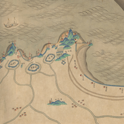
The map is viewed from right to left, from the upper reaches of the Qiantang River to the mouth of the river. The south bank is on the top of the map and the estuary is on the west. The map shows the old and new dikes, seawalls, hills, canals, towns, checkpoints, villages, and temples along the banks of the Qiantang River. The map depicts Qiantang River tidal waves with special emphasis on the section from Hangzhou to Haining. The differences in color reflect differences in silt content on the south bank. The river and bay are known for the distinctive tidal bore. The tide rushing into the narrower river mouth from the bay causes a high bore that can move at speeds of up to 25 miles an hour. The roaring Qiantang tidal bore creates a spectacular scenic view. Haining was designated as a department in the 38th Year of Qing Qianlong Reign (1773); Haining is marked as Haining epartment on the map. Scholars have concluded that the map was made after 1773. No title appeared on the map; the title applied here is based on content.
The map can be studied with the following maps in the National Palace Museum's collection: title: Zou wei gong jin Zhejiang Sheng cheng zhan ming sheng tu kuang and its attachment Jiang Zhe hai tang tu shi gong cheng qing xing tu (NPM file no. 012702); title: Hangzhou tu (map no. 021484); title: Zhejiang Sheng hai tang (map no. 020880); title: Zhejiang Hangzhou Fu diyu tu shuo (map no. 021305); title: Zhejiang Ningbo Fu shu di li yu tu (map no. 021308).
The map can be studied with the following maps in the National Palace Museum's collection: title: Zou wei gong jin Zhejiang Sheng cheng zhan ming sheng tu kuang and its attachment Jiang Zhe hai tang tu shi gong cheng qing xing tu (NPM file no. 012702); title: Hangzhou tu (map no. 021484); title: Zhejiang Sheng hai tang (map no. 020880); title: Zhejiang Hangzhou Fu diyu tu shuo (map no. 021305); title: Zhejiang Ningbo Fu shu di li yu tu (map no. 021308).