Flood Control and Embankment Maps
永寧縣河圖
Map of the river systems in Yongning County| Hanyu Pinyin | Yongning Xian he tu |
|---|---|
| Creator | Anonymous |
| Date | Qing Yongzheng to Qianlong period, 1734-1779 |
| Measurement | |
| Techniques | Ink and color manuscript |
| Material | silk |
| Quantity | |
| Categories | |
| Country of Repository | |
| Identifier | Library of Congress |
| Link to Original Database | http://lccn.loc.gov/gm71005162 |
| Acquisition Source | Hummel, Arthur William, 1884-1975 |
| Acquisition Method | |
| Acquisition Date | 1934 |
| Share |
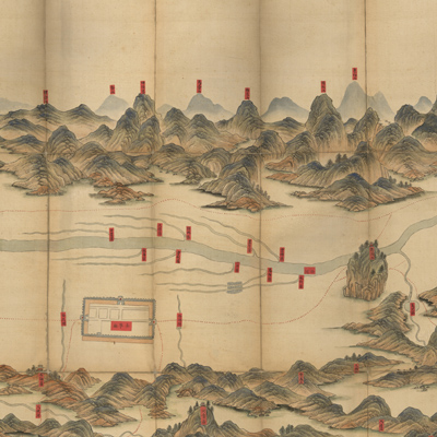
This is one of a series of eleven country river maps of Henan Prefecture. North is at the bottom. Drawn in traditional Chinese landscape style, the map depicts the mountains, cities, villages, and roads of Yongning County in Henan Prefecture, Henan Province. Roads are represented by red dotted lines, the city with pictorial walls. There are no annotations on the map except red text labels indicating place names with emphasis on rivers, tributaries, and canals.
The map can be studied with the following maps in the National Palace Museum's collection: title: Henan quan sheng dao li tu (map no. 021578-021579); title: Henan Henan Fu dao li tu (map no. 021438); title: Henan Sheng di tu (map no. 021446).
The map can be studied with the following maps in the National Palace Museum's collection: title: Henan quan sheng dao li tu (map no. 021578-021579); title: Henan Henan Fu dao li tu (map no. 021438); title: Henan Sheng di tu (map no. 021446).