Flood Control and Embankment Maps
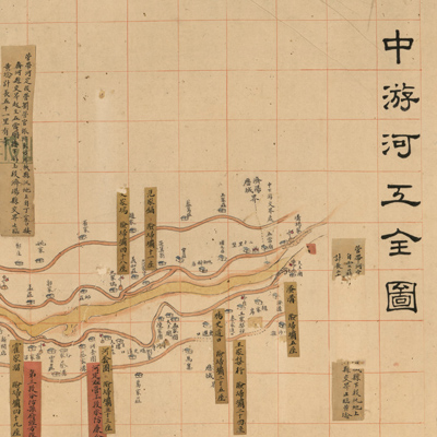
中游河工全圖
Complete map of the Yellow River embankment project| Hanyu Pinyin | Zhong you he gong quan tu |
|---|---|
| Creator | Anonymous |
| Date | Late Qing period, 1898-1903 |
| Measurement | |
| Techniques | Ink and color manuscript |
| Material | paper |
| Quantity | |
| Categories | |
| Country of Repository | |
| Identifier | Library of Congress |
| Link to Original Database | http://lccn.loc.gov/gm71002470 |
| Share |
The map depicts engineering projects along the middle reaches of the Yellow River. The Yellow River levees broke at Tongwaxiang in the 5th Year of Qing Xianfeng Reign (1855) and merged with the Daqing River. The map is oriented with north toward the upper left; the left bank of the Yellow River is at the top. The scroll expands from upstream to downstream, right to left. The first map on the right depicts the lower reaches of the Yellow River. The map covers the area from downriver at Jiyang, Shangdong Province to the upriver junction of Shouzhang and Yanggu County.
The Yellow River is shown in yellow; the Grand Canal and tributaries in graygreen; county boundaries in dotted lines; different symbols are used to distinguish various villages and forts. There are several kinds of annotations: yellow labels indicate treacherous locations, number of forts, names of foremen, and distance mileage to the embankments. Red labels record county officials who oversaw the river fortification projects, and the range and mileage of the projects. Some labels have fallen off the map; their content is unknown.
The map can be studied with the following map in the National Palace Museum's collection: title: Xinhe fen liu pang zhu bing qiang xiang shao gong qing xing tu (Grand Council file no. 033650).