Flood Control and Embankment Maps
六省黃河埽埧河道全圖
The Yellow River embankment map for six provinces| Hanyu Pinyin | Liu sheng Huang He shao ba he dao quan tu |
|---|---|
| Creator | Anonymous |
| Date | Mid-Qing Dynasty, 1824-1825 |
| Measurement | |
| Techniques | Ink and color manuscript |
| Material | paper |
| Quantity | |
| Categories | |
| Country of Repository | |
| Identifier | Library of Congress |
| Link to Original Database | http://lccn.loc.gov/gm71002474 |
| Share |
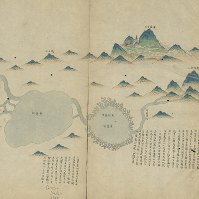
The map is oriented with north on the bottom and depicts the Yellow River from its source in the Bayan Har Mountains in Qinghai Province to the Huai River downstream where the Yellow River joins the sea. It covers six provinces: Gansu, Shaanxi, Shanxi, Henan, Shandong, and Jiangnan. The map shows mountains, rivers, canals, lakes, cities and towns, and the Great Wall along the Yellow River valley. It also identifies the Yellow River's source in “the Bayan Har Mountains”, accompanied by the annotation, “The Yellow River comes from the Altan River, east of Bayan Har Mountains and it flows more than three thousand li, ... passing Lanzhou Prefecture, into the Chinese border.”
The map emphasizes the section of the Yellow River from Wuzhi County in Henan to the mouth of river. It depicts embankments, fascine dams, forts, and other projects on both banks of the Yellow River, including detailed descriptions of levee breaks at specific locations, fort boundaries, the length of embankments, and number of forts.
The map can be studied with the following maps in the National Palace Museum's collection: title: Liu sheng Huang He shao ba qing xing tu (map no. 020884); title: Huang He fa yuan zhi Henan Sheng ge ting gong cheng qing xing tu (map no. 020882); title: Jiangnan Sheng Huang He ge ting shu he dao gong cheng qing xing tu (map no. 020883).