Flood Control and Embankment Maps
銅瓦廂以下黃河穿運隄工圖貼說
Illustrated map of the Yellow River's embankment project in Tongwaxiang| Hanyu Pinyin | Tongwaxiang yi xia Huang He chuan yun di gong tu tie shuo |
|---|---|
| Creator | Zeng Guoquan |
| Date | Qing Guangxu period, 1875-1876 |
| Measurement | |
| Techniques | Ink and color manuscript |
| Material | paper |
| Quantity | |
| Categories | |
| Country of Repository | |
| Identifier | Library of Congress |
| Link to Original Database | http://lccn.loc.gov/gm71002482 |
| Acquisition Source | Hummel, Arthur William, 1884-1975 |
| Acquisition Method | |
| Acquisition Date | 1962 |
| Share |
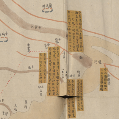
Notes on margins indicate orientation, and north is on the bottom. The map depicts the Yellow River dam burst in Tongwaxiang in 1855 (the 5th Year of Qing Xianfeng Reign); the river flowed through the northeast town of Zhangqiuzhen and merged with the Grand Canal. The map covers the flood-affected areas from Longmen in Lanyi County to the Daqing River in Dong'a County. Embankment construction sites are indicated with annotated yellow labels that describe locations and lengths; the blockage of river channels is illustrated by shades of yellow.
The north flowing Yellow River cut off the Grand Canal's stream near Zhangqiuzhen inYanggu County. The Yellow River's branches and tributaries dominated the region; the Grand Canal joined the Yellow River water force and gradually built up silt on the riverbed. The Grand Canal was divided into two watercourses where the canal and river merged: one went south to Shilibao; the other surged north to Balimiao. Boats carrying grain to the capital travelled south via the Yellow River to the intersection and then travelled north against the current to Balimiao. The silt build-up near the entrance of the Grand Canal was so high in 1881 that a new entrance was constructed at Taochengbu. Boats bypassed the town of Zhangqiuzhen soon after. The map, with a yellow satin cover, is annotated in black ink: “subject Zeng Guoquan respectfully submits the report to Your Majesty.” Zeng Guoquan (1824-1890, style name Yuan Fu) was appointed river governor in the 1st Year of Qing Guangxu Reign (1875), and presided over Yellow River dike repair work; he was transferred to serve as Shanxi governor in 1877. The map was drawn when during Zeng's tenure as river governor between 1875-1877.
The map can be studied with the following maps in the National Palace Museum's collection: title: Bei an si ting gong cheng zong he tu (map no. 020890); title: Xin he fen liu pang zhu bing qiang xiang shao gong qing xing tu (Grand Council file no. 033650).