Flood Control and Embankment Maps
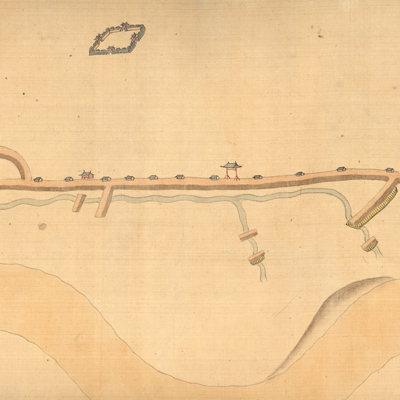
豫省黃河南岸堤垻工程圖
Map of embankment project of the Yellow River| Hanyu Pinyin | Yu Sheng Huang He nan an di ba gong cheng tu |
|---|---|
| Creator | Anonymous |
| Date | Qing Guangxu period, 1875- |
| Measurement | |
| Techniques | Ink and color manuscript |
| Material | silk scroll |
| Quantity | |
| Categories | |
| Country of Repository | |
| Identifier | Library of Congress |
| Link to Original Database | http://lccn.loc.gov/gm71005025 |
| Acquisition Source | Hummel, Arthur William, 1884-1975 |
| Acquisition Method | |
| Acquisition Date | 1930 |
| Share |
No title appears on the map; the title applied here is based on content; there is no annotation on the map. The map is considered unfinished. It depicts watercourses, levees, and fascine works along the river; it is inferred that the map is an embankment map of the south bank of the Yellow
River from Kaifeng to Lanyang.
It can be studied with the following maps in the National Palace Museum's collection: title: Yu Sheng Huang He nan an di nian zhang zhang he shi qing xing quan tu (map no. 020885); title: Bei an si ting gong cheng zong he tu (map no. 020890); title: Lanyang bei an Tongwaxiang gong zhuo fang shui xiang xing tu (Grand Council file no. 040879); title: Yi kao nan bei liang an di ba ge gong qing xing tu (Grand Council file no. 030159-a); title: Suining Xiang Huanghe nan an zhou jia lou di gong man yi qing xing tu (Grand Council file no. 040923); title: Lanyang bei an shui shi gong cheng tu (Grand Council file no. 009463); title: Chou ban Zhoujialou man kou guo tou bing tiao shui ju yin qu qing xing tu (Grand Council file no. 041004); title: Lanyi Xian Huanghe gong cheng tu (Grand Council file no. 138485); title: Yu sheng xing he xian zai liu shi qing xing tu (Grand Council file no. 034347) ; title: Yi kao er xun man gong cao tu (Grand
Council file no. 022802-1) ; title: Xin he fen liu pang zhu bing qiang xiang shao gong qing xing tu (Grand Council file no. 033650).