Flood Control and Embankment Maps
河北道屬光緒二年黃河形勢做過工程全圖
The Yellow River northern embankment enginerring map for Hebei Province| Hanyu Pinyin | Hebei dao shu Guangxu er nian Huanghe xing shi zuo guo gong cheng quan tu |
|---|---|
| Creator | Anonymous |
| Date | The 2nd Year of Qing Guangxu Reign, 1876 |
| Measurement | |
| Techniques | Ink and color manuscript |
| Material | paper |
| Quantity | |
| Categories | |
| Country of Repository | |
| Identifier | Library of Congress |
| Link to Original Database | http://lccn.loc.gov/80692831 |
| Acquisition Source | Hummel, Arthur William, 1884-1975 |
| Acquisition Method | |
| Acquisition Date | 1962 |
| Share |
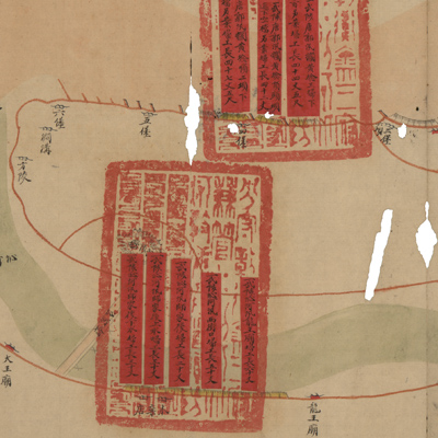
The map expands from right to left and orientations are noted along the river; north is on the bottom. The map covers the area from Tangguoxun, Wuzhi County in the west to the junction of Huangqinting Yuanwuxun and Beiweiliangting Yangwuxun in the east. The map depicts the waterways under Hebei jurisdiction and fortification and fascine construction on the north shore from Wuzhi County to Lanyang County where the Yellow River burst its bank. Construction sites are identified by pasted red labels that describe fascine construction and the project length. The official seals attached to the red labels are written in Manchu and Chinese.
This is a comprehensive map of Hebei Province and its four sub-prefectures on the north bank of the Yellow River.
The map can be studied with the following maps in the National Palace Museum's collection: title: Liu sheng Huang He sao ba qing xing tu (map no. 020884); title: Yu Sheng Huang He nan an di nian sao ba zhang zhang he shi qing xing quan tu (map no. 020885); title: Gui mao nian Yu Sheng Huang He nan an di nian sao ba zhang zhang he shi qing xing quan tu (map no. 020886); title: Bing wu nian Yu Sheng Huang He nan an di nian sao ba zhang zhang he shi qing xing quan tu (map no. 020887); title: Ding wei nian Yu Sheng Huang He nan an di nian sao ba zhang zhang he shi qing xing quan tu (map no. 020888); title: Hebei dao shu Huang He bei an ge ting he shi gong cheng qing xing tu (map no. 020889).