Flood Control and Embankment Maps
南岸三廳光緒二年分河道起止里數做過工程段落丈尺總河圖
The Yellow River southern embankment project map for Nan'ansan sub-prefecture| Hanyu Pinyin | Nan an san ting Guangxu er nian fen he dao qi zhi li shu zuo guo gong cheng duan luo zhang chi zong he tu |
|---|---|
| Creator | Anonymous |
| Date | The 2nd Year of Qing Guangxu Reign, 1876 |
| Measurement | |
| Techniques | Ink and color manuscript |
| Material | paper |
| Quantity | |
| Categories | |
| Country of Repository | |
| Identifier | Library of Congress |
| Link to Original Database | http://lccn.loc.gov/80692830 |
| Acquisition Source | Hummel, Arthur William, 1884-1975 |
| Acquisition Method | |
| Acquisition Date | 1962 |
| Share |
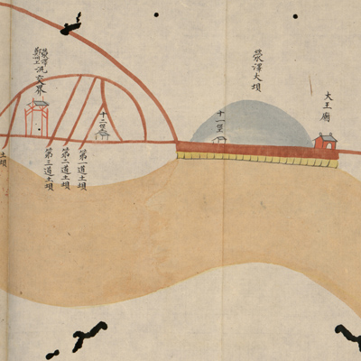
According to the red labels, the map covers the area from the west bank of Yingzexun to Lanyangxun in the east. The total length of embankment is more than 271 li (approximately 85 miles).
The map depicts the Yellow River's south embankment and various construction sites. Red labels are affixed to describe embankments, reinforcements, construction sites, construction length, and construction officials. The official seals attached to the red labels are written in Manchu and Chinese. Extra efforts were made to identify the construction sites even when the labels fell off.
The map can be studied with the following maps in the National Palace Museum's collection: title: Liu sheng Huang He sao ba qing xing tu (map no. 020884); title: Yu Sheng Huang He nan an di nian sao ba zhang zhang he shi qing xing quan tu (map no. 020885); title: Gui mao nian Yu Sheng Huang He nan an di nian sao ba zhang zhang he shi qing xing quan tu (map no. 020886); title: Bing wu nian Yu Sheng Huang He nan an di nian sao ba zhang zhang he shi qing xing quan tu (map no. 020887); title: Ding wei nian Yu Sheng Huang He nan an di nian sao ba zhang zhang he shi qing xing quan tu (map no. 020888).