Flood Control and Embankment Maps
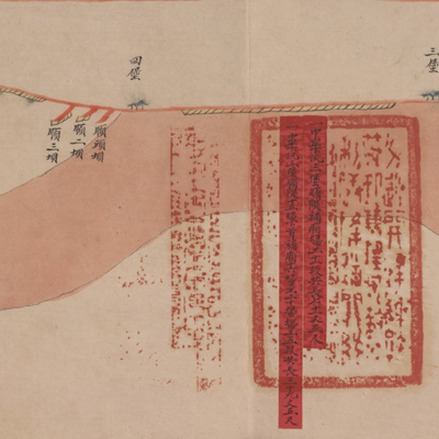
中河廳屬光緒元年分補廂中牟下汛三堡順堤埽工題估河圖
The Yellow River southern embankment cost estimate map for Zhonghe sub-prefecture| Hanyu Pinyin | Zhong he ting shu Guangxu yuan nian fen bu xiang zhong mou xia xun fan san bao shun di sao gong ti gu he tu |
|---|---|
| Creator | Anonymous |
| Date | The 1st Year of Qing Guangxu Reign, 1875 |
| Measurement | |
| Techniques | Ink and color manuscript |
| Material | paper |
| Quantity | |
| Categories | |
| Country of Repository | |
| Identifier | Library of Congress |
| Link to Original Database | http://lccn.loc.gov/80692833 |
| Acquisition Source | Hummel, Arthur William, 1884-1975 |
| Acquisition Method | |
| Acquisition Date | 1962 |
| Share |
The map expands from right to left and shows the Yellow River flowing from the west upstream to the east. North is at the bottom. The map covers the area from Toubao and Dawangmiao in the west to Shangxun and Xiaxun of Zhongheting in the east. The map records various types of embankments. The map depicts the location of fortifications and fascine construction along the Yellow River. Red labels pasted on the map identify construction sites and describe fascine construction and project length. The official seals attached to the red labels are written in Manchu and Chinese.
The map can be studied with the following maps in the National Palace Museum's collection: title: “Huang He Zhongheting shu di fang gong cheng ping wen” submitted by Qiao Songnian (Grand Council file no. 111284); title: Huang Yun He gong cheng tu (map no 020891-020910); title: Jingkou yi xia Xiyang Yun He yi dai he hu zhi Hangzhou qing xing (map no. 020881); title: Zhongheting Taoyuanxun bei an xian di man kou chou ban su yu gong cheng qing xing tu (Grand Council file no. 074546).
The map can be studied with the following maps in the National Palace Museum's collection: title: “Huang He Zhongheting shu di fang gong cheng ping wen” submitted by Qiao Songnian (Grand Council file no. 111284); title: Huang Yun He gong cheng tu (map no 020891-020910); title: Jingkou yi xia Xiyang Yun He yi dai he hu zhi Hangzhou qing xing (map no. 020881); title: Zhongheting Taoyuanxun bei an xian di man kou chou ban su yu gong cheng qing xing tu (Grand Council file no. 074546).