Flood Control and Embankment Maps
四省運河水利泉源河道全圖(浙江、江蘇、山東、直隸)
Map of the Grand Canal in four provinces| Hanyu Pinyin | Si sheng Yun He shui li quan yuan he dao quan tu |
|---|---|
| Creator | Anonymous |
| Date | Mid-Qing Dynasty (-1855) |
| Measurement | |
| Techniques | Ink and color manuscript |
| Material | paper |
| Quantity | |
| Categories | |
| Country of Repository | |
| Identifier | Library of Congress |
| Link to Original Database | http://lccn.loc.gov/gm71002475 |
| Share |
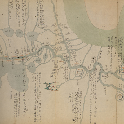
The map covers four provinces: Zhejiang, Jiangsu, Shandong, and Zhili. North is to the left but the map is not consistent with actual orientation. The map depicts the entire Grand Canal in the above provinces and shows major northern watercourses that joined the Canal, such as the Xingsu Sea -- the source of the Yellow River, the Bayan Har mountains, and surrounding areas.
The map describes mountains, cities, lakes, and places; some names are accompanied with explanatory text. The map also depicts other embankment dams, lock-culverts, bridges, towns, hills, villages, temples, and pagodas. Different colors are used for various rivers. The Yellow River, the Yongding River, the Ziya River, the South Canal (including Gunshuiba dam leads channels) are drawn in yellow; the Yangtze River appears in green; the other rivers are in blue. The Yellow River joins the sea through the Huai River. This map depicts the situation before the 5th Year of Qing Xianfeng Reign (1855).
The map can be studied with the following maps in the National Palace Museum's collection: title: Liu sheng Huanghe shao ba qing xing tu (map no 020884); title: Huang He fa yuan zhi Henan Sheng ge ting gong cheng qing xing tu (map no. 020882); title: Ba sheng Yun He quan yuan shui li qing xing tu (map no. 020912).