Local Administrative Maps
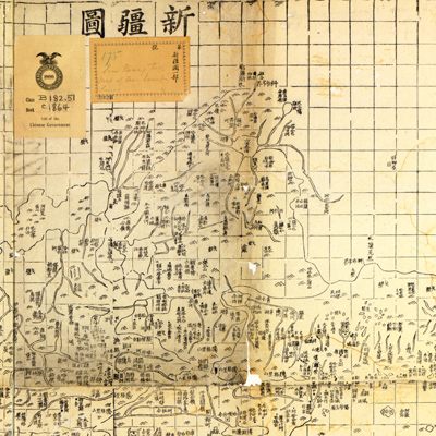
新疆圖
Map of Xinjiang District| Hanyu Pinyin | Xinjiang tu |
|---|---|
| Creator | Hubei Sheng Wuchang chong wen shu ju |
| Date | Qing Tongzhi period, 1867- |
| Measurement | |
| Techniques | Woodcut |
| Material | paper |
| Quantity | |
| Categories | |
| Country of Repository | |
| Identifier | Library of Congress |
| Link to Original Database | http://lccn.loc.gov/gm71005141 |
| Acquisition Source | Chinese government |
| Acquisition Method |
| Share |
The Xinjiang area map is one of 26 maps in “Huang chao zhi sheng di yu quan tu” compiled by Hubei Guan Shu Ju in the 3rd Year of Qing Tongzhi Reign (1864). The description of Xinjiang is too sketchy and dose not cover the southern area of Tian Shan. The map of “Xinjiang tu” by Hubei Sheng Wuchang Chong Wen Shu Ju was included in the reprinted edition.
Mountains and lakes are represented with triangles. Different symbols are used to indicate cities, towns, postal stops, and river distribution systems. The map shows the areas in Xinjiang governed by the mid-nineteenth century Qing government. Geomorphology and urban distribution are also represented.
This map can be studied with the following maps in the National Palace Museum's collection: title: Xinjiang quan sheng yu di tu (purchase no. 002578); title: Xinjinag tu shuo (map no. 021304).