Local Administrative Maps
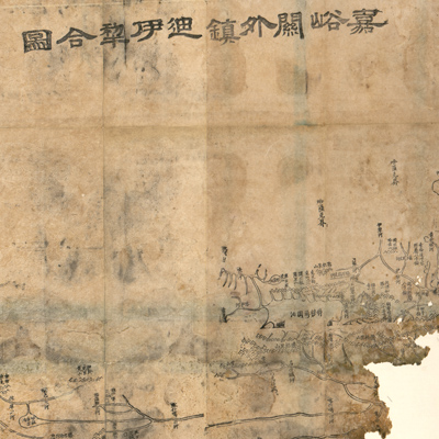
嘉峪關外鎮迪伊犁合圖
Combined map of Dihuazhou and Yili outside of Jiayuguan| Hanyu Pinyin | Jiayuguan wai zhen Di, Yili he tu |
|---|---|
| Creator | Hubei guan shu ju |
| Date | Qing Tongzhi period, 1864 |
| Measurement | |
| Techniques | Woodcut |
| Material | paper |
| Quantity | |
| Categories | |
| Country of Repository | |
| Identifier | Library of Congress |
| Link to Original Database | http://lccn.loc.gov/2002626759 |
| Acquisition Date |
| Share |
Torn at the bottom, a large portion of the lower map is missing. The map is seriously damaged by water stains. The map is not drawn to scale. There isn't a grid nor are there any illustrations or explanatory text. The geomorphology of the mountains is represented with a stacked triangle. Main cities and towns along the roads are marked.
The map is one of 26 maps in “Huang chao zhi sheng di yu quan tu” compiled by Hubei Guan Shu Ju in the 3rd Year of Qing Tongzhi Reign (1864).
This map can be studied with the following maps in the National Palace Museum's collection: title: Gansu di tu (map no. 021507-021508); title: Xinjiang tu shuo (map no. 021304); title: Xinjiang quan sheng tu shuo (purchase no. 002578); title: Gansu zhen zhan shou tu lie (map no. 020920); title: Gansu di fang tu (map no. 021551); title: Yili zhi Keshigeer xin jian cheng tu (document no. 05804); title: Jiayuguan bian qiang tu (Grand Council document no. 041375).