Local Administrative Maps
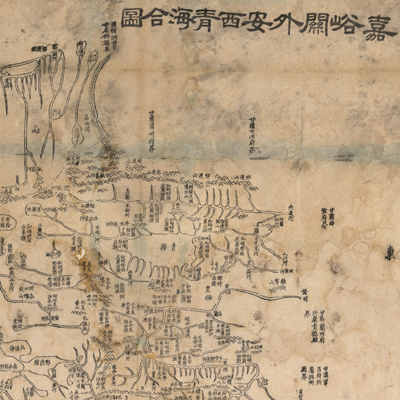
嘉峪關外安西青海合圖
Combined map of Anxi and Qinghai outside of Jiayuguan| Hanyu Pinyin | Jiayuguan wai Anxi Qinghai he tu |
|---|---|
| Creator | Hubei guan shu ju |
| Date | Qing Tongzhi period, 1864 |
| Measurement | |
| Techniques | Woodcut |
| Material | paper |
| Quantity | |
| Categories | |
| Country of Repository | |
| Identifier | Library of Congress |
| Link to Original Database | http://lccn.loc.gov/96685940 |
| Acquisition Date |
| Share |
Orientation is clearly marked on four sides of the map with north to the top, west on the left. The map doesn't use coordinates or the Chinese grid, nor does it use legends or explanatory text. Mountains are represented with a triangle. The map depicts the geomorphology of mountains, rivers, and lakes in Anxi Zhou and Qinghai region outside the Jiayuguan Pass of the Great Wall of western Gansu Province. The map shows major rivers, grazing areas, and the distribution of tusi (tribes). Small circles represent the Yellow River's wetlands near the Zhalinghai Sea and Elinghai Sea. The map is one of 26 maps in “Huang chao zhi sheng di yu quan tu” compiled by Hubei Guan Shu Ju in the 3rd Year of Qing Tongzhi Reign (1864).
This map can be studied with the following maps in the National Palace Museum's collection. Title: Gansu di tu (map no. 021507-021508); title: title: Gansu zhen zhan shou tu lue (map no. 020920); title: Gansu di fang tu (map no. 021551); title: Jiayuguan guan men tu (document no. 041665); title: Jiayuguan bian qiang tu (Grand Council document no. 041375).CC18
This map can be studied with the following maps in the National Palace Museum's collection. Title: Gansu di tu (map no. 021507-021508); title: title: Gansu zhen zhan shou tu lue (map no. 020920); title: Gansu di fang tu (map no. 021551); title: Jiayuguan guan men tu (document no. 041665); title: Jiayuguan bian qiang tu (Grand Council document no. 041375).CC18