Local Administrative Maps
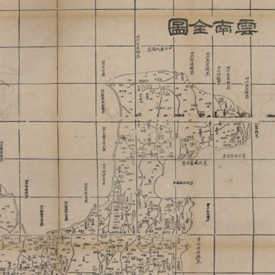
雲南全圖
Complete map of Yunnan Province| Hanyu Pinyin | Yunnan quan tu |
|---|---|
| Creator | Hubei guan shu ju |
| Date | Qing Tongzhi period, 1864 |
| Measurement | |
| Techniques | Woodcut |
| Material | paper |
| Quantity | |
| Categories | |
| Country of Repository | |
| Identifier | Library of Congress |
| Link to Original Database | http://lccn.loc.gov/96685901 |
| Acquisition Date |
| Share |
The map depicts mountains and lakes in Yunnan Province. Text on the top left records the number of prefectures, municipalities, sub-prefectures, and counties. The note also gives distances from cities and towns to the provincial capital, Yunnan Fu, and its distance and location in relation to Shuntian Fu (Beijing). The map uses the Chinese cartographic grid and a side of each grid represents 100 li (approximately 33 miles). The orientation is marked along the borders on all four sides. Different symbols are used to indicate the location of prefectures, municipalities, sub-prefectures, and counties. Major cities and towns are prominently marked. The note also records adjoining states and counties along the border.
The map is one of 26 maps in “Huang chao zhi sheng di yu quan tu” compiled by Hubei Guan Shu Ju in the 3rd Year of Qing Tongzhi Reign (1864).
This map can be studied with the following maps in the National Palace Museum's collection: title: Yunnan quan sheng dao li tu shuo (map no. 021299); title: Yunnan zong tu (map no. 021460-021461); title: Yunnan Sheng di tu (map no. 021478); title:Yunnan yu di tu shuo (map 021302-021303).