Local Administrative Maps
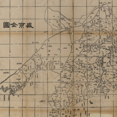
盛京全圖
Map of Shengjing Province| Hanyu Pinyin | Shengjing Quan Tu |
|---|---|
| Creator | Hubei guan shu ju |
| Date | Qing Tongzhi period, 1864 |
| Measurement | |
| Techniques | Woodcut |
| Material | paper |
| Quantity | |
| Categories | |
| Country of Repository | |
| Identifier | Library of Congress |
| Link to Original Database | http://lccn.loc.gov/gm71005114 |
| Acquisition Date |
| Share |
The title is pasted on the back of the map; north is on top and the orientation is marked along the borders on four sides. The map adopts the Chinese cartographic grid and a side of each grid represents 100 li (approximately 33 miles). The map depicts Shengjing province's mountains, rivers, and coastal landforms. Administrative divisions are marked with different symbols; major cities and towns, checkpoints of the Great Wall and forts along border regions are prominently marked. The text on the bottom right describes prefectures and counties in the province; it also records number of prefectures, departments, sub-prefectures, and counties. The note also gives distances from cities and towns to the provincial capital, and explains the distance and location of Fengtian Fu in relation to the capital Jingshi (Beijing).
The map was made by Hubei Guan Shu Ju, and it is a part of“Huang chao zhi sheng di yu quan tu” compiled in the 3rd Year of Qing Tongzhi Reign (1864). The whole set consists of 26 map sheets, which are fairly accurate maps made in the late nineteenth century, utilizing the traditional Chinese cartographic grid. The administrative division data is of the 1st Year of Tongzhi Reign(1862).
This map can be studied with the following maps in the National Palace Museum's collection: title: Shengjing cheng tu (map 021318); title: Shengjing wu lu tu* (map no. 021548, map no 021550, map no. 021565, map no. 021567, and map no. 021568); title: Shengjing wei chang tu (Grand Council document no. 057611).
* In Chinese and Manchu language