Local Administrative Maps
吉林輿圖
Map of Jilin Province| Hanyu Pinyin | Jilin yu tu |
|---|---|
| Creator | Anonymous |
| Date | Qing Guangxu period 1882-1889 |
| Measurement | |
| Techniques | Ink and color manuscript |
| Material | |
| Quantity | |
| Categories | |
| Country of Repository | |
| Identifier | Library of Congress |
| Link to Original Database | http://lccn.loc.gov/gm71002468 |
| Acquisition Source | Hummel, Arthur William, 1884-1975 |
| Acquisition Method | |
| Acquisition Date | 1930 |
| Share |
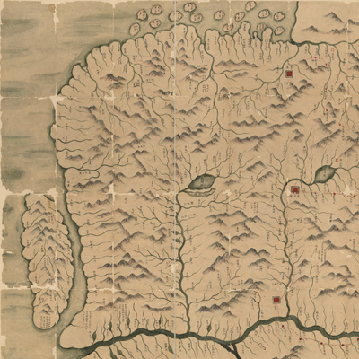
Part of the map is missing. East is oriented to the left and north to the bottom. The map covers the entire territory under the jurisdiction of the Qing Dynasty General of Jilin. The map depicts the following places from southwest to northeast: Wangqingmen, Yingemen, Huoersumen, Yitongmen, Barannifoluomen, coastal areas and islands from Tumenjiang estuary to Heilongjiang estuary, including Sakhalin, and south of Huntongjiang (Heilongjiang).
The Songhua River, the Mudan River, and the Ussuri River are emphasized. Six lieutenant generals are stationed along the rivers in jurisdictions, such as Jilin, Ningguta, Alechuke, Baidu(na)cheng, Sanxingcheng, and Hunchun. They are depicted with red squares. Various round or square symbols represent different administrative divisions. Changbai Mountain is emphasized with prominent features; Xinkai Lake (ie Xingkaihu) and Abo Lake are particularly marked, Sakhalin Island is drawn with a special annotation: "There are twenty-one villages (tun) on the island and three ethnic groups live here: Sakhalin, Feiyake, and Elunchun." Based on the information gathered from the map, the map was made during the Guangxu period (1882-1889).
This map can be studied with the following maps in the National Palace Museum's collection: title: Shuang cheng bao la lin tu shi (Grand Council document no. 120709); title: Yitonghe kan fen jie zhi tu (Grand Council document no. 120710); title: Mopanshan kan she fen fang tu (Grand Council document no. 120711); title: Jilin jiu he tu* (map no. 021457); title: Heilongjian liu yu tu (map no. 021456); title: Ninguta di tu (map no. 021465-021467); title: Jilin wei chang jie zhi tu (Grand Council document no. 057612).
* In Manchu language