Local Administrative Maps
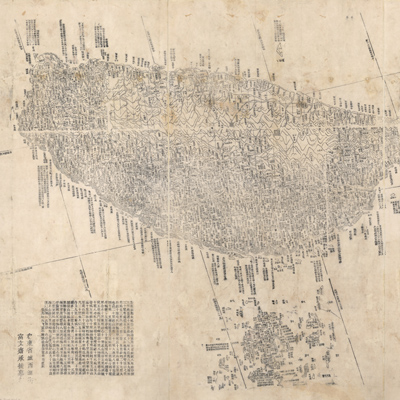
全臺前後山輿圖
Map of Taiwan Island| Hanyu Pinyin | Taiwan qian hou shan yu tu |
|---|---|
| Creator | Yu Chong |
| Date | Qing Guangxu period, 1878 |
| Measurement | |
| Techniques | Woodcut |
| Material | paper |
| Quantity | |
| Categories | |
| Country of Repository | |
| Identifier | Library of Congress |
| Link to Original Database | http://lccn.loc.gov/gm71005160 |
| Acquisition Source | Mr. C. C. Chen |
| Acquisition Method | |
| Acquisition Date | 21915 |
| Share |
Beijing serves as the prime meridian and a traditional Chinese square grid is depicted. East is on top with north to the left. A bottom note indicates the square grid is a scaling device, with each side of a square representing 10 li (or about 5 km). The map legend explains signs. The text on the bottom describes the west and east coast of the island and distances in between. Descriptive drawings depict rivers, mountains, cities, and towns. The map also records in great detail the names for islands, ports, tide levels, water depths, flood control measures, and the army garrison. A note indicates that the map was made in the 4th Year of Guangxu Reign (1878) by Jiaping Committee member Yu Chong.
This map can be studied with two maps and documents from the National Palace Museum's collection. Title: Taiwan tu fu Penghu qun dao (made in Yongzheng period, map no. 020794); title: Taiwan di tu (made in Qianlong period, map no. 020795); Grand Council archive Shen Baozhen's report “Progress on building mountain roads, pacifying remote ethnic groups, and fortifying coastal defense”(Grand Council file no. 115999); and Shen Baozhen's report on "Fortifying Taiwan's coastal defense, building new roads and other national affairs” (Grand Council document no.116000).
This map can be studied with two maps and documents from the National Palace Museum's collection. Title: Taiwan tu fu Penghu qun dao (made in Yongzheng period, map no. 020794); title: Taiwan di tu (made in Qianlong period, map no. 020795); Grand Council archive Shen Baozhen's report “Progress on building mountain roads, pacifying remote ethnic groups, and fortifying coastal defense”(Grand Council file no. 115999); and Shen Baozhen's report on "Fortifying Taiwan's coastal defense, building new roads and other national affairs” (Grand Council document no.116000).