Local Administrative Maps
臺灣地里圖
Geographical map of Taiwan Island| Hanyu Pinyin | Taiwan di li tu |
|---|---|
| Creator | Anonymous |
| Date | Qing Kangxi period, 1684- |
| Measurement | |
| Techniques | Ink and color manuscript |
| Material | silk |
| Quantity | |
| Categories | |
| Country of Repository | |
| Identifier | Library of Congress |
| Link to Original Database | http://lccn.loc.gov/gm71005037 |
| Acquisition Source | Hummel, Arthur William, 1884-1975 |
| Acquisition Method | |
| Acquisition Date | 1930 |
| Share |
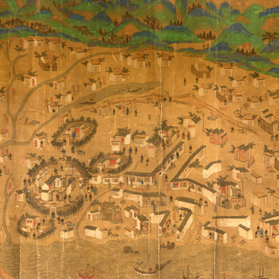
This is a pictorial view with east on top and north to the left. The view uses traditional map drawing methods to depict the mountains, rivers, cities, and towns of Taiwan Island and Penghu Islands (Pescadores Island). The three-dimensional walls indicate defensive walls for army units stationed there; houses symbolize government offices and distribution of villages. Mountains, waves, and passing ships are shown pictorially. The map is comparble to “Kangxi Taiwan yu tu” housed at the Taiwan History Museum. There is no wall in Zhulo on the museum map. The map depicts Taixia Road (1684-1727, Taixia Road later changed to Taiwan Road) and Taiwan Zhen, established in 1684.
This map can be studied with three maps from the National Palace Museum's collection: title: Taiwan lue tu* (map no. 201444 and map no. 021445); title: Taiwan tu fu Penghu qun dao tu (Map of Taiwan and Penhu Islands; made in Yongzheng period; map no. 020794); and title: Taiwan di tu (made in Qinglong period, map no. 020795).
* in Chinese and Manchu language