Local Administrative Maps
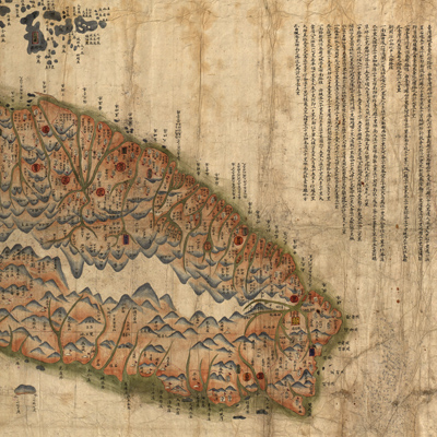
臺灣前後山全圖
Map of Taiwan Island| Hanyu Pinyin | Taiwan qian hou shan quan tu |
|---|---|
| Creator | Li Liankun |
| Date | Qing Guangxu period, 1880 |
| Measurement | |
| Techniques | Ink and color manuscript |
| Material | |
| Quantity | |
| Categories | |
| Country of Repository | |
| Identifier | Library of Congress |
| Link to Original Database | http://lccn.loc.gov/gm71005066 |
| Acquisition Source | Hummel, Arthur William, 1884-1975 |
| Acquisition Method | |
| Acquisition Date | 1934 |
| Share |
Taiwan Island faces Mainland China with north oriented to the right. The text shows roads on both sides of the mountain, including the distances between Taipei and other provincial capital cities, between Taiwan Fu to Hengchun Xian, and distances of three newly built roads: southern, northern, and central. The map resembles a landscape painting that depicts Taiwan Island as a whole, surrounding islands, and Penghu Islands (Pescadores Islands) with their geographic locations and distribution of cities and towns. A line of red dots indicates roads; the coastal islands note the distances of waterways; ports and harbors annotate tide levels, flood control, and military defenses of the Qing army. The map also makes reference to reclamation in Taiwan from northern, southern, and central mountain roads and reflects the Qing Dynasty's road building and pacification of remote areas in the 13th Year of Tongzhi Reign (1874). An imperial commissioner was appointed to handle Taiwan's coastal defense.
This map can be studied with maps and documents from the National Palace Museum's collection: title: Map of Taiwan and Penghu Islands (made in Yongzheng period, map no. 020794); title: Taiwan Map (made in Qianlong period, map no. 020795); Grand Council archive Shen Baozhen's report “Progress on building mountain roads, pacifying remote ethnic groups, and
fortifying coastal defense”(Grand Council file no. 115999); and Shen Baozhen's report on "Fortifying Taiwan's coastal defense, building new roads and other national affairs” (Grand Council document no.116000).