Local Administrative Maps
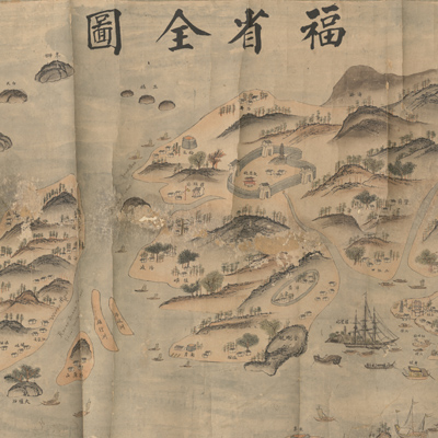
福省全圖
Map of Fujian Province| Hanyu Pinyin | Fu sheng quan tu |
|---|---|
| Creator | Anonymous |
| Date | late Qing period, 1842-1884 |
| Measurement | |
| Techniques | Ink and color manuscript |
| Material | paper |
| Quantity | |
| Categories | |
| Country of Repository | |
| Identifier | Library of Congress |
| Link to Original Database | http://lccn.loc.gov/gm71002477 |
| Acquisition Date |
| Share |
The map of Fujian doesn't cover the entire province, but only the provincial capital area, and Lianjiang, Changle County. The map depicts the provincial capital Fuzhou City, the location of mountains, rivers, islands, ports, villages, towns, forts in the vicinity of Zhongzhou and Wuhumen (from Nantai to Minjiang Estuary) and Chinese army units stationed in the fortress. The English translation of annotated place names is in black ink with the English title penciled in as “ Chinese map of Foo chou & its suburbs.” The English text is believed to have been written by the map's one-time owner, Thomas Dunn, who was the American counsel in Fuzhou (1858-73).
This map can be studied with the following maps in the National Palace Museum's collection: title: Zhejiang Fujian yan hai hai fang tu (map no. 020869); title: Fujian Sheng di tu (map no. 021476); title: Yan hai an chang tu (map no. 020868); title: Min sheng cheng nan men wai zhi di tu (Grand Council document no. 129322); title: Min Jiang Mawei hai zhan chao xi tu (Grand Council document no. 129323).
This map can be studied with the following maps in the National Palace Museum's collection: title: Zhejiang Fujian yan hai hai fang tu (map no. 020869); title: Fujian Sheng di tu (map no. 021476); title: Yan hai an chang tu (map no. 020868); title: Min sheng cheng nan men wai zhi di tu (Grand Council document no. 129322); title: Min Jiang Mawei hai zhan chao xi tu (Grand Council document no. 129323).