Local Administrative Maps
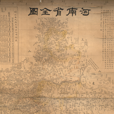
河南省全圖
Complete map of Henan Province| Hanyu Pinyin | Henan quan tu |
|---|---|
| Creator | Yang Ziming |
| Date | Qing Guangxu Period, 1895 |
| Measurement | |
| Techniques | Lithograph and hand colored |
| Material | paper |
| Quantity | |
| Categories | |
| Country of Repository | |
| Identifier | Library of Congress |
| Link to Original Database | http://lccn.loc.gov/gm71002471 |
| Acquisition Date |
| Share |
Prefatory notes state that the map was made by Yang Ziming in April, the 21st Year of Guangxu Reign (1895). It provides ample evidence of Western influences on map drawing skills, such as Western mapping techniques and the influence of Western cartography, astronomy, and geography. The prime meridian is Jingshi (Beijing) and coordinates are 7°W/2°E / 31°N /38°N. The map also incorporates the traditional Chinese cartographic grid; a side of each grid represents 100 li (approximately 33 miles). The map covers the mountains, rivers, administrative divisions (ting, fu, zhou, xian), flood control stations, major roads, and telephone lines of Henan Province. Different symbols indicate the levels of administrative planning and landscape. There are three explanatory texts attached to the map:
(1) Sunrise/sunset timetables in nine prefectures of Henan Province; (2) the
conversion table for grid (equivalent mileage of each grid area, etc.); and (3)
the legend.
This map can be studied with the following maps in the National Palace Museum's collection: title: Henan Sheng di tu (map no. 021446); title: Henan quan sheng dao li tu (map no. 021578-021579).