Local Administrative Maps
甘肅輿圖
Map of Gansu Province| Hanyu Pinyin | Gansu yu tu |
|---|---|
| Creator | Anonymous |
| Date | Qing Xianfeng, Tongzhi period, 1855-1871 |
| Measurement | |
| Techniques | Ink and color manuscript |
| Material | |
| Quantity | |
| Categories | |
| Country of Repository | |
| Identifier | Library of Congress |
| Link to Original Database | http://lccn.loc.gov/gm71002479 |
| Acquisition Source | Hummel, Arthur William, 1884-1975 |
| Acquisition Method | |
| Acquisition Date | 1930 |
| Share |
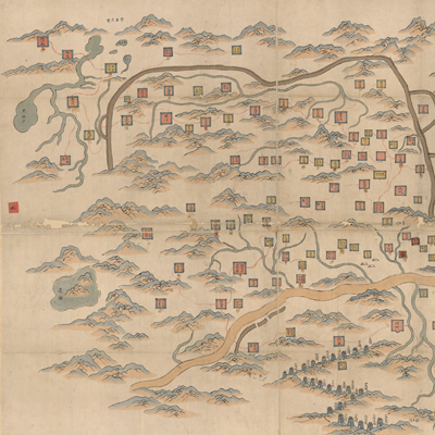
The orientation is marked along the borders on all four sides; north is at the top. There is no scale or legend on the map. Mountains and rivers are shown pictorially. Different colored square symbols represent all levels of government: province, prefecture, state, department, county, local administration, camp, fort, inspection station, etc. The map indicates the roads in red double dotted lines, the Great Wall in brown double lines, the Yellow River in yellow, and other rivers in light blue. The map also identifies the Yellow River Bridge, near the provincial capital Lanzhou, the twenty-four checkpoints of Hezhou Zhen, and forests along the edge of the mountains.
This map can be studied with the following maps in the National Palace Museum's collection: title: Gansu quan sheng dao li zong tu (map no. 0214474, and map no. 021448); title: Gansu di tu (map no. 021507, map no. 021508); title: Gansu di fang tu (map no. 021551); title: Huanghe Lanzhou fu qiao tu (map no. 021515); title: Lanzhou Hualinshan he zhou yi dai qing shi tu (Grand Council no. 031541); title: Lanzhou fang mian xian zai wei gong zei ying qing xing tu (Grand Council no. 031542); title: Lanzhou Hualinshan yi dai qing shi tu (Grand Council no. 031543); title: Lanzhou cheng wai Haulinshang yi dai xing shi quan tu (map no. 031544).
This map can be studied with the following maps in the National Palace Museum's collection: title: Gansu quan sheng dao li zong tu (map no. 0214474, and map no. 021448); title: Gansu di tu (map no. 021507, map no. 021508); title: Gansu di fang tu (map no. 021551); title: Huanghe Lanzhou fu qiao tu (map no. 021515); title: Lanzhou Hualinshan he zhou yi dai qing shi tu (Grand Council no. 031541); title: Lanzhou fang mian xian zai wei gong zei ying qing xing tu (Grand Council no. 031542); title: Lanzhou Hualinshan yi dai qing shi tu (Grand Council no. 031543); title: Lanzhou cheng wai Haulinshang yi dai xing shi quan tu (map no. 031544).