Local Administrative Maps
瓊郡輿地全圖
Complete map of Hainan Island| Hanyu Pinyin | Qiong Jun yu di quan tu |
|---|---|
| Creator | Anonymous |
| Date | Mid-Qing period, -1836 |
| Measurement | |
| Techniques | Ink and color manuscript |
| Material | |
| Quantity | |
| Categories | |
| Country of Repository | |
| Identifier | Library of Congress |
| Link to Original Database | http://lccn.loc.gov/gm71002478 |
| Share |
Qiongzhou's administrative divisions followed the lineage inherited from the Ming and Qing dynasties with minor changes. There were three states and thirteen counties since the 19th of Ming Hongwu 19 (1386). According to “Qiongzhou fu zhi, yang ge” by Xiao Yingzhi in the 40th Year of Qing Qianlong Reign (1775), the three states were Wanzhou, Danzhou, and Yaizhou; the ten counties were Qiongshan, Chengmai, Lingao, Dingan, Wenchang, Lehui, Huitong, Changhua, Lingshui, and Ganen. Changes were made in the 31st Year of Qing Guangxu Reign (1905): Yaizhou was promoted to Zhilizhou, Wanzhou was demoted to Wan County, and then along with the counties of Ganen, Linshui, and Changwua was combined to Yaizhou.
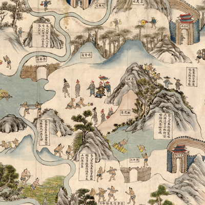
The map is oriented with north to the bottom, and the pictorial representation is distorted. The purpose of these kinds of maps is not for recording accurate geographic locations and roads, but to describe cultural customs of folk lives just like the map “Fan su tu.” The map depicts natural and manmade features, including mountains, walled tribes, harbors, pavilion towers, the outline of city walls, flood control, forts, and other buildings. The annotation describes the indigenous Li people's food, clothing, housing, transportation, and cultural customs. The notes along the images are complemented by drawings of the Li people engaged in various activities and Qing Dynasty officials stationed in Qiongzhou.
According to “Qiongzhou fu zhi, hai fang zhi” by Ming Yi and Zhang Yue
Song in the 21st Year of Qing Daoguang Reign (1841), navy officer Zhan Yu Chun proposed to build a new fort in Danzhou to patrol the western sea and the proposal was approved in the 16th Year of Qing Daoguang Reign (1836). However, the map does not reflect the new fort in Danzhou; therefore, the date of the map apparently is before the 16th Year of Qing Daoguang Reign (1836).
This map can be studied with the following maps in the National Palace Museum's collection: title: Guangdong Sheng di tu (map no. 021477).