Local Administrative Maps
直隸山東兩省地輿全圖
Complete map of Zhili and Shandong| Hanyu Pinyin | Zhi li shan dong liang sheng di yu quan tu |
|---|---|
| Creator | Anonymous |
| Date | Qing Xianfeng, Tongzhi period, 1855-1870 |
| Measurement | |
| Techniques | Ink and color manuscript |
| Material | |
| Quantity | |
| Categories | |
| Country of Repository | |
| Identifier | Library of Congress |
| Link to Original Database | http://lccn.loc.gov/gm71005076 |
| Acquisition Source | Hummel, Arthur William, 1884-1975 |
| Acquisition Method | |
| Acquisition Date | 1934 |
| Share |
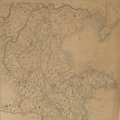
The title “Zhili Shangdong liang sheng di yu quan tu” is affixed to the verso of the map. The map is oriented with north at the top and south on the bottom. The map covers Zhili and Shandong provinces of Bohai Sea, Shengjing Province of Liaodong Peninsula, and the eastern Shanxi province. Relief is shown pictorially. Mountains, river systems, administrative divisions, watercourses, roads, and the Great Wall are drawn in detail. Fu (prefecture), zhou (department), ting (sub-prefecture), xian (county), and shi (city) are represented by different symbols and various colors. Official roads, postal roads, roads, or bypass roads are distinguished by different drawing styles, such as brown double lines, red lines, or black dotted lines. The map gives distance information between the two places.
The Yellow River changed course in the 5th Year of Xianfeng Reign (1855); the Yellow River's course in northern Subei is marked as the “Old Yellow River.”
This map can be studied with the following maps in the National Palace Museum's collection: title: Zhili Shandong Henan san sheng quan tu (purchase no. 002579-002583); title: Bohai yan an dao li tu (map no. 021471).