General Maps
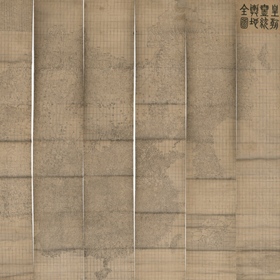
皇朝一統輿地全圖
Qing Empire's complete map of all under heaven| Hanyu Pinyin | Huang chao yi tong yu di quan tu |
|---|---|
| Creator | Liu Yan |
| Date | Qing Daoguang Period, 1842 |
| Measurement | |
| Techniques | Wood block printing in red and black |
| Material | paper |
| Quantity | |
| Categories | |
| Country of Repository | |
| Identifier | Library of Congress |
| Link to Original Database | http://lccn.loc.gov/gm71005054 |
| Acquisition Source | Hummel, Arthur William, 1884-1975 |
| Acquisition Method | |
| Acquisition Date | 1930 |
| Share |
The title “Huang Chao Yi Tong Yu Di Quan Tu” is on the top right corner; the map is mounted on eight scrolls. Extensive postscripts explained the origin and history of this map. Liu Yan's map is based on the map made by Li Zhaoluo (1769-1841) in Daoguang 12 nian (1832). The map uses the Chinese cartographic grid and a side of each grid represents 100 li” (approximately 33 miles). Wood block printing is in red and black; red indicates coordinates and place names. Black represents the grid and other important map features.
The map can be studied with the following maps in the National Palace Museum's collection: title: Shi san pai tong ban di tu (map no. 021049-021156); title: Zhongguo di tu (map no. 021504); title: Da Qing wan nian yi tong tian xia quan tu (purchase document no. 002503-002510); title: Huang chao yi tong yu di quan tu (purchase document no. 002800-002807).
The map can be studied with the following maps in the National Palace Museum's collection: title: Shi san pai tong ban di tu (map no. 021049-021156); title: Zhongguo di tu (map no. 021504); title: Da Qing wan nian yi tong tian xia quan tu (purchase document no. 002503-002510); title: Huang chao yi tong yu di quan tu (purchase document no. 002800-002807).