General Maps
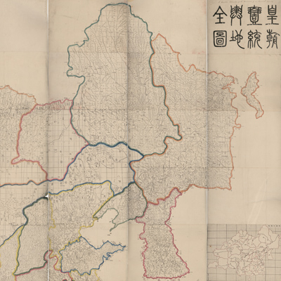
皇朝一統輿地全圖
Qing Empire's complete map of all under heaven| Hanyu Pinyin | Huang chao yi tong yu di quan tu |
|---|---|
| Creator | Dong Fangli, Li Zhaoluo |
| Date | Qing Daoguang period, 1832 |
| Measurement | |
| Techniques | Woodcut |
| Material | paper |
| Quantity | |
| Categories | |
| Country of Repository | |
| Identifier | Library of Congress |
| Link to Original Database | http://lccn.loc.gov/gm71002481 |
| Share |
The map is copied from “Nei Fu Yu Tu” of the Kangxi and Qianlong period. The province, county, and waterway changes up to Daoguang 2 nian (1822) were added to the map based on official gazetteers. Li Zhaoluo used eight woodcuts to assemble one map. The map includes text on the upper left; both coordinates and a Chinese cartographic grid were used. Red dotted lines indicate coordinates while solid lines indicate a grid. The prime meridian is Beijing. The maps cover the area from Sakhalin Island in the east to the Congling (now called Pamirs) in the west, from Heilongjiang River along the borders of China and Russia in the north to Hainan Island in the South China Sea. The map features boundaries, administrative divisions, and neighboring countries. Only the administrative level of counties and above is represented, and the province boundaries are colored differently to distinguish them.
The map can be studied with the following maps in the National Palace Museum's collection: title: Shi san pai tong ban di tu (map no. 021049-021156); title:
Zhongguo di tu (map no. 021504); title: Da Qing wan nian yi tong tian xia quan tu (purchase document no. 002503-002510); title: Huang chao yi tong yu di quan
tu (purchase document no. 002800-002807).