General Maps
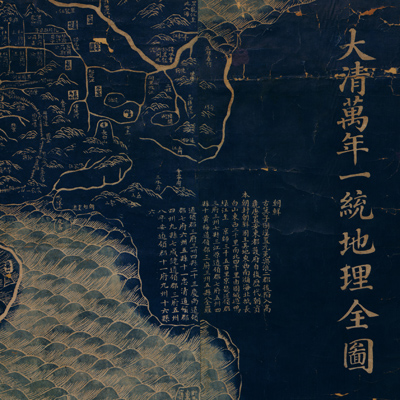
大清萬年一統地理全圖
Complete geographical map of the great Qing Dynasty| Hanyu Pinyin | Da Qing wan nian yi tong di li quan tu |
|---|---|
| Creator | Xu Zhidao |
| Date | Qing Jiaqing period, 1814-1816 |
| Measurement | |
| Techniques | Lithograph, blue |
| Quantity | |
| Categories | |
| Country of Repository | |
| Identifier | Library of Congress |
| Link to Original Database | http://lccn.loc.gov/gm71005060 |
| Share |
According to the text on the right of the map, the map was based on another map drawn by Huang Qianren (1694-1771) from Yuyao. (His style name was Zhengsun and his grandfather was Huang Zongyi, father Huang Baijia). A side of each grid represents 100 li (approximately 33 miles) written on the lower right of the map, but there isn't any cartographic grid drawn on the map. The entire map depicts the mountains, rivers, boundaries, and established checkpoints of the mid-Qing era Great Wall. Each country is identified by adjacent circled notes. Different graphic symbols indicate administrative divisions. The map focuses on two rivers, the Yellow and Yangtze. The origin of the Yellow River is drawn correctly; however the map still shows Minjiang River as the source of the Yangtze River, which repeats the old legend and is not correct. The unique
characteristic of the map is that it uses positive (Yang) engraving patterns for the administrative divisions while the mountains, rivers, and islands are drawn in negative (Yin) engraving patterns.
The map can be studied with the following three maps in the National Palace Museum's collection: title: Shi san pai tong ban di tu (map no. 021049-021156); title: Zhongguo di tu (map no. 021504); title: Da Qing wan nian yi tong tian xia quan tu (purchase document no. 002503-002510); title: Huang chao yi tong yu di quan tu (purchase document no. 002800-002807).