General Maps
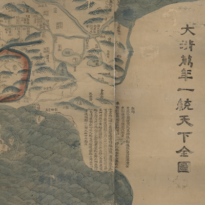
大清萬年一統天下全圖
The great Qing Dynasty's complete map of all under heaven| Hanyu Pinyin | Da Qing wan nian yi tong tian xia quan tu |
|---|---|
| Creator | Anonymous |
| Date | Qing Jiaqing Period, 1811 |
| Measurement | |
| Techniques | Woodcut and hand colored |
| Material | paper |
| Quantity | |
| Categories | |
| Country of Repository | |
| Identifier | Library of Congress |
| Link to Original Database | http://lccn.loc.gov/gm71005018 |
| Acquisition Source | Hummel, Arthur William, 1884-1975 |
| Acquisition Method | |
| Acquisition Date | 1930 |
| Share |
The note along the right side of the map explains that it is based on the map drawn by Huang Qianren (1694-1771) from Yuyao. (His style name was Zhengsun; his grandfather was Huang Zongyi, and his father was Huang Baijia.)
The map depicts Qing Dynasty administrative divisions and boundaries. The bordering region and the neighboring countries are also featured, such as Congling (also known as Pamirs, which is a general term for Pamir Plateau, Kunlun Mountain, Karakoram Mountains and its west mountain range), the Atlantic Ocean, Russia, Shendu Guo (ancient name of India), Xingluo (Siam), Japan, and
Korea. European countries are noted in small circles on the left; symbols of the Great Wall, major rivers, boundaries, railways, mountains, rivers, and landscape icons appear in the legend. The most significant feature is a railway symbol in the northeast section of the map. Mountains are shown pictorially. Different symbols
represent miscellaneous administrative divisions in different colors. The source of the Yellow River consists of the Xingsu Sea, Eling Lake, and Chaling Lake.
The map can be studied with the following maps in the National Palace Museum's collection: title: Shi san pai tong ban di tu (map no. 021049-021156); title: Zhongguo di tu (map no. 021504); title: Da Qing wan nian yi tong tian xia quan tu (purchase document no. 002503-002510); title: Huang chao yi tong yu di quan tu (purchase document no. 002800-002807).