General Maps
大清廿三省輿地全圖:附朝鮮州道輿地圖
Complete map of the twenty-three provinces of the great Qing Dynasty with a provincial map of Korea| Hanyu Pinyin | Da Qing er shi san sheng yu di quan tu: fu Chaoxian zhou dao yu di tu |
|---|---|
| Creator | Anonymous |
| Date | Qing Guangxu period, 1885-1895 |
| Measurement | |
| Techniques | Woodcut in color |
| Material | paper |
| Quantity | |
| Categories | |
| Country of Repository | |
| Identifier | Library of Congress |
| Link to Original Database | http://lccn.loc.gov/gm71005068 |
| Share |
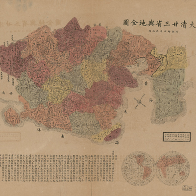
The map depicts the national territory of the late Qing Dynasty, including twenty-three provinces and the distribution of the administrative divisions of prefectures, departments, and counties. The map legend is an explanatory list of the symbols
for provincial capitals, prefectural, county, state and departmental seats. In addition, symbols for the Great Wall, major rivers, boundaries, railways, mountains, rivers, and landscapes appear in the legend. A unique feature includes a symbol for a railway in the northeast. The map describes the administrative divisions in Choson. The map is oriented with north toward the upper right; however, the orientation is distorted and the description of a number of locations is incorrect. Place names assigned to Taiwanese locations are completely inaccurate.
The map can be studied with the following maps in the National Palace Museum's collection: title: Shi san pai tong ban di tu (map no. 021049-021156); title: Zhongguo di tu (map no. 021504); title: Da Qing wan nian yi tong tian xia quan tu (purchase document no. 002503-002510); title: Huang chao yi tong yu di
quan tu (purchase document no. 002800-002807).