General Maps
皇輿全覽分省圖
The Kangxi provincial atlas of China| Hanyu Pinyin | Huang yu quan lan fen sheng tu |
|---|---|
| Creator | Anonymous |
| Date | Qing Kangxi period, 1693-1722 |
| Measurement | |
| Techniques | Ink and color manuscript |
| Material | |
| Quantity | |
| Categories | |
| Country of Repository | |
| Identifier | Library of Congress |
| Link to Original Database | http://lccn.loc.gov/2002626779 |
| Acquisition Source | William Woodville Rockhill |
| Acquisition Method | |
| Acquisition Date | 1884 |
| Share |
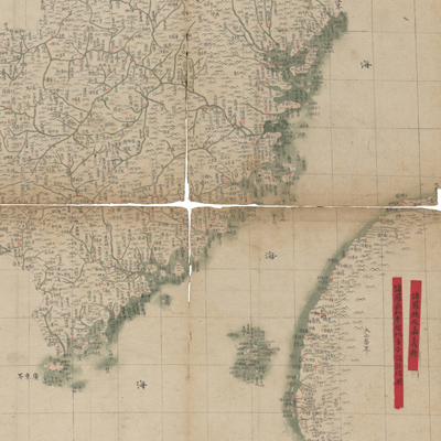
The prime meridian of this map set is Beijing with latitude and longitude coordinates. Each individual map is subtitled, including Zhili, Shengjing, Shandong, Shanxi, Jiangnan, Jiangxi, Zhejiang, Henan, Huguang, Fujian, Guangdong, Guangxi, Sichuan, Yunan, and Guizhou. There are fifteen maps in total, excluding a map of Shanxi. Red and darkish green lines indicate rivers. Two notes in red ink are pasted on the map of Fujian and Taiwan and provide the following information: “Zhuluo Xian is changed to Jiayi Xian” and “Zhanghua Xian is established in the northern area of Zhuluo Xian”.
This map set can be studied with two maps of the National Palace Museum's collection for reference: title: Shi san pai tong ban di tu (map no. 021049-021156) and title: Zhili tu (map no. 021481).
This map set can be studied with two maps of the National Palace Museum's collection for reference: title: Shi san pai tong ban di tu (map no. 021049-021156) and title: Zhili tu (map no. 021481).