General Maps
天下圖
Cheonhado (Map of all under Heaven)| Hanyu Pinyin | Da Ming hun yi tian xia quan tu |
|---|---|
| Creator | Anonymous |
| Date | 17th century |
| Measurement | |
| Techniques | Ink and color manuscript |
| Material | paper |
| Quantity | |
| Categories | |
| Country of Repository | |
| Identifier | Library of Congress |
| Link to Original Database | http://lccn.loc.gov/93684246 |
| Share |
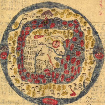
The manuscript map was based on an original map by Yang Ziqi (dates unknown, style name Mingfu), but Yang's map of “Ba yu di tu” did not include the Korean Kingdom. The map shows the territory of the Ming Dynasty, Beijing, Nanjing, and thirteen provinces. The map on the right is copied from the
chapter“Map of heaven and earth” in the well-known book“Classic of Mountains and Seas”. The countries shown on this map are consistent with the countries mentioned in the “Classic of Mountains and Seas”.
The text on the verso has nothing to do with the map; they are simply random scrawls. The piece of paper sticking to the map might be original paper from Ming Dynasty.